Geolocate

Link Sar topographic map

Click on the map to display elevation.

About this map

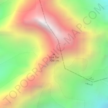
Name: Link Sar topographic map, elevation, terrain.

Location: Link Sar, Gilgit-Baltistan, Pakistan (35.44394 76.59598 35.44404 76.59608)

Average elevation: 19,308 ft

Minimum elevation: 15,856 ft

Maximum elevation: 22,805 ft

Other topographic maps

Click on a map to view its topography, its elevation and its terrain.

Hunza District

Pakistan > Gilgit-Baltistan

Average elevation: 14,797 ft

Astore Tehsil

Pakistan > Gilgit-Baltistan > Astore District

Average elevation: 12,454 ft

Astore District

Pakistan > Gilgit-Baltistan

Average elevation: 12,231 ft

Hunza River

Pakistan > Gilgit-Baltistan > Minapin Nagar

Average elevation: 8,855 ft

Shigar River

Pakistan > Gilgit-Baltistan > Skardu

Average elevation: 9,465 ft

Gear up for your next adventure:

🔥Plasma Lighters - Windproof lighters that work in any weather condition
🧼Biodegradable Camping Soap - Eco‑friendly soap for outdoor hygiene
🕶️Glacier Sunglasses - Side shields to protect eyes from high-altitude snow glare
🚗GPS Dash Cams - Record your scenic drives through mountain passes and canyons
📚USA Hiking Guide Books - Top trail guides and map books

As an Amazon Associate, this site earns from qualifying purchases at no extra cost to you.