
Invermere topographic map
Click on the map to display elevation.
About this map
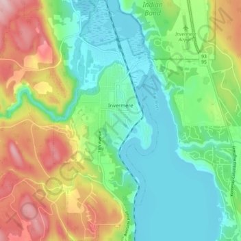
Name: Invermere topographic map, elevation, terrain.
Average elevation: 2,874 ft
Minimum elevation: 2,608 ft
Maximum elevation: 3,369 ft
Other topographic maps
Click on a map to view its topography, its elevation and its terrain.
Blue Lake
Canada > British Columbia > Regional District of East Kootenay > Area A (Upper Flathead/Elk Valley)
Average elevation: 4,692 ft
Baynes Lake
Canada > British Columbia > Regional District of East Kootenay > Area B (Lake Koocanusa)
Average elevation: 2,612 ft
Fairmont Hot Springs
Canada > British Columbia > Regional District of East Kootenay > Area F (Columbia Lake/Windermere Lake)
Average elevation: 3,018 ft
Topaz Lake
Canada > British Columbia > Regional District of East Kootenay > Area G (Forster Creek/Mount Assiniboine)
Average elevation: 3,770 ft
Mount Connor
Canada > British Columbia > Regional District of East Kootenay > Area A (Upper Flathead/Elk Valley)
Average elevation: 8,091 ft
Kootenay National Park
Canada > British Columbia > Regional District of East Kootenay
Kootenay National Park is a national park of Canada in southeastern British Columbia. The park consists of 1,406 km2 (543 sq mi) of the Canadian Rockies, including parts of the Kootenay and Park mountain ranges, the Kootenay River and the entirety of the Vermilion River. While the Vermilion River is completely…
Average elevation: 6,010 ft
Whiteswan Lake
Canada > British Columbia > Regional District of East Kootenay > Area F (Columbia Lake/Windermere Lake)
Average elevation: 4,567 ft
Taurus Mountain
Canada > British Columbia > Regional District of East Kootenay > Area G (Forster Creek/Mount Assiniboine)
Average elevation: 7,887 ft
Corbin
Canada > British Columbia > Regional District of East Kootenay > Area A (Upper Flathead/Elk Valley)
Average elevation: 5,364 ft
Elkford
Canada > British Columbia > Regional District of East Kootenay > Elkford > Elkford
Average elevation: 5,066 ft
Minnow Creek
Canada > British Columbia > Regional District of East Kootenay > Area G (Forster Creek/Mount Assiniboine)
Average elevation: 4,685 ft
Goldrun Lake
Canada > British Columbia > Regional District of East Kootenay > Area C (Moyie/Bull River)
Average elevation: 6,250 ft
Mount Patrick
Canada > British Columbia > Regional District of East Kootenay > Area E (Saint Mary/Skookumchuck)
Average elevation: 7,201 ft