
Make a donation
Gear up for your next adventure:
As an Amazon Associate, this site earns from qualifying purchases at no extra cost to you.
Ararat Province topographic map
Click on the map to display elevation.
Make a donation
Gear up for your next adventure:
As an Amazon Associate, this site earns from qualifying purchases at no extra cost to you.
About this map
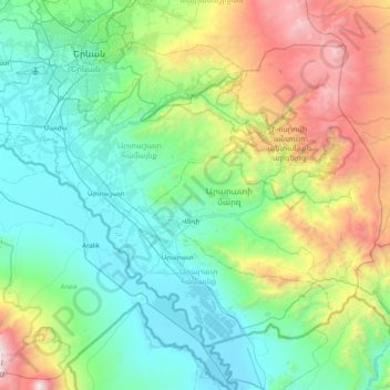
Name: Ararat Province topographic map, elevation, terrain.
Location: Ararat Province, Armenia (39.71367 44.31221 40.19142 45.11220)
Average elevation: 4,941 ft
Minimum elevation: 2,612 ft
Maximum elevation: 12,723 ft
Make a donation
Gear up for your next adventure:
As an Amazon Associate, this site earns from qualifying purchases at no extra cost to you.
Other topographic maps
Click on a map to view its topography, its elevation and its terrain.
Make a donation
Gear up for your next adventure:
As an Amazon Associate, this site earns from qualifying purchases at no extra cost to you.
Aragats
Mount Aragats has a topographic prominence of 2,143 meters, more than some higher mountains, such as Dykh-Tau (5,205 m high) in the Russian part of Great Caucasus Range.
Average elevation: 11,959 ft
Vardenis
Armenia > Gegharkunik Province
Located in the valley of the Masrik River at an elevation of 2006 meters above sea level, Vardenis is dominated by the 82-kilometre (51 mi) range of Vardenis Mountains. The highest peak of the range is Mount Vardenis at 3,522 metres (11,555 ft) above sea level, located around 23 km southwest of Vardenis town.…
Average elevation: 6,394 ft
Make a donation
Gear up for your next adventure:
As an Amazon Associate, this site earns from qualifying purchases at no extra cost to you.
Make a donation
Gear up for your next adventure:
As an Amazon Associate, this site earns from qualifying purchases at no extra cost to you.
Make a donation
Gear up for your next adventure:
As an Amazon Associate, this site earns from qualifying purchases at no extra cost to you.
Aparan
Modern-day Aparan is located at the eastern slopes of Mount Aragats and the northern slopes of Mount Ara, on the shores of Kasagh River, with an elevation of 1880 metres above sea level. The town is located at a road distance of 42 km north of Yerevan and 32 km north of the provincial capital Ashtarak, on the…
Average elevation: 6,362 ft
Make a donation
Gear up for your next adventure:
As an Amazon Associate, this site earns from qualifying purchases at no extra cost to you.
Make a donation
Gear up for your next adventure:
As an Amazon Associate, this site earns from qualifying purchases at no extra cost to you.
Make a donation
Gear up for your next adventure:
As an Amazon Associate, this site earns from qualifying purchases at no extra cost to you.
Make a donation
Gear up for your next adventure:
As an Amazon Associate, this site earns from qualifying purchases at no extra cost to you.
Vardenis
Armenia > Gegharkunik Province
Located in the valley of the Masrik River at an elevation of 2006 meters above sea level, Vardenis is dominated by the 82-kilometre (51 mi) range of Vardenis Mountains. The highest peak of the range is Mount Vardenis at 3,522 metres (11,555 ft) above sea level, located around 23 km southwest of Vardenis town.…
Average elevation: 6,394 ft
Make a donation
Gear up for your next adventure:
As an Amazon Associate, this site earns from qualifying purchases at no extra cost to you.
Make a donation
Gear up for your next adventure:
As an Amazon Associate, this site earns from qualifying purchases at no extra cost to you.
Gyumri
Gyumri is 126 kilometres (78 miles) north of the capital Yerevan at the central part of the Shirak plateau. It has an approximate height of 1,550 metres (5,090 feet) above sea level, the high altitude line being 1,500 metres (4,900 feet). The Akhurian River passes through the western suburbs. The Shirak…
Average elevation: 5,075 ft
Make a donation
Gear up for your next adventure:
As an Amazon Associate, this site earns from qualifying purchases at no extra cost to you.
Kapan
The town is about 80 km (50 mi) north of the Iranian border. With a height of 3201 meters, Mount Khustup is the highest peak of the region. The elevation of Kapan is 750–1050 meters above sea level, with an average height of 910 meters. Two tributaries of the Voghji River, Vachagan and Kavart, flow through…
Average elevation: 3,642 ft
Make a donation
Gear up for your next adventure:
As an Amazon Associate, this site earns from qualifying purchases at no extra cost to you.
Halidzor
Geographically, Halidzor is located near the left bank of the Vorotan River, at an altitude of 1300-1350 m above sea level. The regional center of Syunik province - the city of Kapan, is 62 km away. The nearest town is Goris, which is 12 km to the southwest.
Average elevation: 4,350 ft
Make a donation
Gear up for your next adventure:
As an Amazon Associate, this site earns from qualifying purchases at no extra cost to you.
Make a donation
Gear up for your next adventure:
As an Amazon Associate, this site earns from qualifying purchases at no extra cost to you.
Make a donation
Gear up for your next adventure:
As an Amazon Associate, this site earns from qualifying purchases at no extra cost to you.
Aparan
Modern-day Aparan is located at the eastern slopes of Mount Aragats and the northern slopes of Mount Ara, on the shores of Kasagh River, with an elevation of 1880 metres above sea level. The town is located at a road distance of 42 km north of Yerevan and 32 km north of the provincial capital Ashtarak, on the…
Average elevation: 6,362 ft
Gyumri
Armenia > Shirak Province > Gyumri
Gyumri is 126 kilometres (78 miles) north of the capital Yerevan at the central part of the Shirak plateau. It has an approximate height of 1,550 metres (5,090 feet) above sea level, the high altitude line being 1,500 metres (4,900 feet). The Akhurian River passes through the western suburbs. The Shirak…
Average elevation: 5,036 ft
Make a donation
Gear up for your next adventure:
As an Amazon Associate, this site earns from qualifying purchases at no extra cost to you.
Make a donation
Gear up for your next adventure:
As an Amazon Associate, this site earns from qualifying purchases at no extra cost to you.
Make a donation
Gear up for your next adventure:
As an Amazon Associate, this site earns from qualifying purchases at no extra cost to you.
Make a donation
Gear up for your next adventure:
As an Amazon Associate, this site earns from qualifying purchases at no extra cost to you.