
Diablo Lake topographic map
Click on the map to display elevation.
Diablo Lake
Diablo Lake is a reservoir in the North Cascade mountains of northern Washington state, United States. Created by Diablo Dam, the lake is located between Ross Lake and Gorge Lake on the Skagit River at an elevation of 1,201 feet (366 m) above sea level. Diablo Lake is part of the Skagit River Hydroelectric Project and managed by Seattle City Light.
About this map
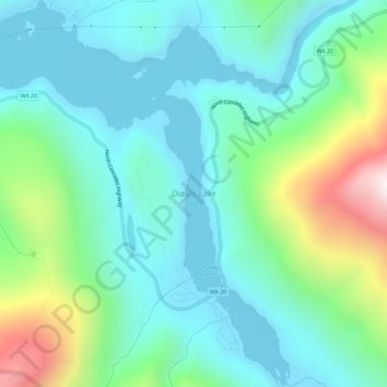
Name: Diablo Lake topographic map, elevation, terrain.
Location: Diablo Lake, Whatcom County, Washington, United States (48.68160 -121.13257 48.72013 -121.08459)
Average elevation: 2,110 ft
Minimum elevation: 1,188 ft
Maximum elevation: 5,046 ft
Other topographic maps
Click on a map to view its topography, its elevation and its terrain.
Tomyhoi Peak
United States > Washington > Whatcom County
The nearest higher peak is Canadian Border Peak, 2.4 miles (3.9 km) to the northeast. Precipitation runoff on the east side of Tomyhoi Peak drains into Tomyhoi Lake and Tomyhoi Creek, whereas the west side of the mountain drains into Damfino Creek, all eventually reaching the Chilliwack River in Canada.…
Average elevation: 5,184 ft
Mount Redoubt
United States > Washington > Whatcom County
The North Cascades features some of the most rugged topography in the Cascade Range with craggy peaks, spires, ridges, and deep glacial valleys. Geological events occurring many years ago created the diverse topography and drastic elevation changes over the Cascade Range leading to the various climate…
Average elevation: 6,791 ft
Ruby Mountain
United States > Washington > Whatcom County
Ruby Mountain is a prominent 7,412-foot (2,259-metre) mountain summit located in the North Cascades Range of Washington state. It is situated in Ross Lake National Recreation Area which is part of the North Cascades National Park Complex. The Diablo Lake Overlook along the North Cascades Highway is at the foot…
Average elevation: 5,679 ft
Bellingham
United States > Washington > Whatcom County > Bellingham
According to the United States Census Bureau, the city has a total area of 28.90 square miles (74.85 km2), of which, 27.08 square miles (70.14 km2) is land and 1.82 square miles (4.71 km2) is water. The lowest elevations are at sea level along the waterfront. Alabama Hill is one of the higher points in the…
Average elevation: 423 ft