
Make a donation
Gear up for your next adventure:
As an Amazon Associate, this site earns from qualifying purchases at no extra cost to you.
Cheyenne Bottoms topographic map
Click on the map to display elevation.
Make a donation
Gear up for your next adventure:
As an Amazon Associate, this site earns from qualifying purchases at no extra cost to you.
About this map
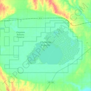
Name: Cheyenne Bottoms topographic map, elevation, terrain.
Location: Cheyenne Bottoms, Barton County, Kansas, United States (38.43539 -98.77465 38.52160 -98.58997)
Average elevation: 1,821 ft
Minimum elevation: 1,772 ft
Maximum elevation: 1,955 ft
Barton County trails, hiking, mountain biking, running and outdoor activities
Make a donation
Gear up for your next adventure:
As an Amazon Associate, this site earns from qualifying purchases at no extra cost to you.
Other topographic maps
Click on a map to view its topography, its elevation and its terrain.
Make a donation
Gear up for your next adventure:
As an Amazon Associate, this site earns from qualifying purchases at no extra cost to you.