
Town of Stony Point topographic map
Interactive map
Click on the map to display elevation.
About this map
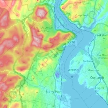
Name: Town of Stony Point topographic map, elevation, terrain.
Average elevation: 390 ft
Minimum elevation: -118 ft
Maximum elevation: 1,293 ft
Other topographic maps
Click on a map to view its topography, its elevation and its terrain.
Village of Spring Valley
United States > New York > Rockland County
Village of Spring Valley, Town of Ramapo, Rockland County, New York, 10977, United States
Average elevation: 489 ft
Village of West Haverstraw
United States > New York > Rockland County > Town of Haverstraw
Village of West Haverstraw, Town of Haverstraw, Rockland County, New York, United States
Average elevation: 203 ft
Evans Park Trail/Woods
United States > New York > Rockland County > Pearl River
Evans Park Trail/Woods, Pearl River, Town of Orangetown, Rockland County, New York, United States
Average elevation: 269 ft
Valley Cottage
United States > New York > Rockland County
Valley Cottage, Town of Clarkstown, Rockland County, New York, 10989, United States
Average elevation: 207 ft
Rockland Lake
United States > New York > Rockland County > Congers
Rockland Lake, Congers, Town of Clarkstown, Rockland County, New York, 10920, United States
Average elevation: 190 ft
Thiells
United States > New York > Rockland County > Town of Haverstraw
Thiells, Town of Haverstraw, Rockland County, New York, 10984, United States
Average elevation: 374 ft
Tomkins Cove
United States > New York > Rockland County > Town of Stony Point
Tomkins Cove, Town of Stony Point, Rockland County, New York, 10986, United States
Average elevation: 223 ft
Village of Pomona
United States > New York > Rockland County > Town of Haverstraw
Village of Pomona, Town of Haverstraw, Rockland County, New York, United States
Average elevation: 610 ft
Sparkill
United States > New York > Rockland County
Sparkill, Town of Orangetown, Rockland County, New York, 10976, United States
Average elevation: 98 ft
Village of Wesley Hills
United States > New York > Rockland County
Village of Wesley Hills, Town of Ramapo, Rockland County, New York, United States
Average elevation: 538 ft
Nanuet
United States > New York > Rockland County
Nanuet, Town of Clarkstown, Rockland County, New York, 10954, United States
Average elevation: 341 ft
New City Park
United States > New York > Rockland County > New City
New City Park, New City, Town of Clarkstown, Rockland County, New York, 10956, United States
Average elevation: 325 ft
Tappan
United States > New York > Rockland County
Tappan, Town of Orangetown, Rockland County, New York, 10983, United States
Average elevation: 112 ft
Buckberg
United States > New York > Rockland County > Town of Stony Point
Buckberg, Town of Stony Point, Rockland County, New York, 10986, United States
Average elevation: 354 ft
Lake Welch
United States > New York > Rockland County > Town of Stony Point
Lake Welch, Town of Stony Point, Rockland County, New York, United States
Average elevation: 1,063 ft
Village of Nyack
United States > New York > Rockland County
Village of Nyack, Town of Orangetown, Rockland County, New York, 10960, United States
Average elevation: 164 ft
Garnerville
United States > New York > Rockland County > Village of West Haverstraw
Garnerville, Village of West Haverstraw, Town of Haverstraw, Rockland County, New York, 10923, United States
Average elevation: 262 ft
Bear Mountain State Park
United States > New York > Rockland County > Town of Stony Point
Bear Mountain State Park, Town of Stony Point, Town of Highlands, Rockland County, New York, United States
Average elevation: 545 ft
Village of Montebello
United States > New York > Rockland County
Village of Montebello, Town of Ramapo, Rockland County, New York, 10901, United States
Average elevation: 489 ft
Village of Piermont
United States > New York > Rockland County
Village of Piermont, Town of Orangetown, Rockland County, New York, 10968, United States
Average elevation: 125 ft
Town of Clarkstown
United States > New York > Rockland County
Town of Clarkstown, Rockland County, New York, United States
Average elevation: 197 ft
New City
United States > New York > Rockland County
New City, Town of Clarkstown, Rockland County, New York, 10956, United States
Average elevation: 292 ft
Suffern
United States > New York > Rockland County > Suffern > Suffern
Suffern, Town of Ramapo, Rockland County, New York, 07495, United States
Average elevation: 522 ft
Village of Suffern
United States > New York > Rockland County
Village of Suffern, Town of Ramapo, Rockland County, New York, United States
Average elevation: 374 ft
West Nyack
United States > New York > Rockland County
West Nyack, Town of Clarkstown, Rockland County, New York, 10994, United States
Average elevation: 151 ft
Mount Ivy
United States > New York > Rockland County
Mount Ivy, Town of Haverstraw, Rockland County, New York, 10970, United States
Average elevation: 404 ft
Monsey
United States > New York > Rockland County
Monsey, Town of Ramapo, Rockland County, New York, 10952, United States
Average elevation: 564 ft
Airmont
United States > New York > Rockland County > Airmont
Airmont, Town of Ramapo, Rockland County, New York, 10982, United States
Average elevation: 479 ft
Palisades
United States > New York > Rockland County > Palisades > Palisades
Palisades, Town of Orangetown, Rockland County, New York, 10964, United States
Average elevation: 118 ft
Stony Point
United States > New York > Rockland County > Stony Point
Stony Point, Town of Stony Point, Rockland County, New York, 10980, United States
Average elevation: 233 ft
Village of Hillburn
United States > New York > Rockland County
Village of Hillburn, Town of Ramapo, Rockland County, New York, 10931, United States
Average elevation: 597 ft
Doodletown
United States > New York > Rockland County > Doodletown
Doodletown, Town of Stony Point, Rockland County, New York, 10911, United States
Average elevation: 584 ft
Village of Upper Nyack
United States > New York > Rockland County
Village of Upper Nyack, Town of Clarkstown, Rockland County, New York, United States
Average elevation: 200 ft
Orangeburg
United States > New York > Rockland County
Orangeburg, Town of Orangetown, Rockland County, New York, 10962, United States
Average elevation: 220 ft
Village of Haverstraw
United States > New York > Rockland County > Town of Haverstraw
Village of Haverstraw, Town of Haverstraw, Rockland County, New York, 10927, United States
Average elevation: 144 ft