
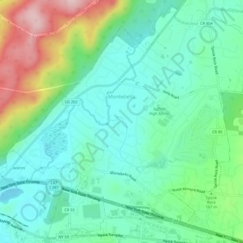
Village of Montebello topographic map
Interactive map
Click on the map to display elevation.
About this map
Name: Village of Montebello topographic map, elevation, terrain.
Average elevation: 489 ft
Minimum elevation: 253 ft
Maximum elevation: 1,083 ft
Numerous winter activities exist along with active wildlife and forestry conservation projects. Guided tours available by the Park Rangers. There is a diverse topography, from flat wetlands to rolling hills, to steep mountainside. The Mahwah River flows southwesterly the length of the park approximately 2,500 feet (760 m). The Ramapo Fault runs through the park. Trees include willow, apple, poplar, white pine, hemlock, beech, maple, white ash, oaks, and dogwood.
Other topographic maps
Click on a map to view its topography, its elevation and its terrain.
Village of Spring Valley
United States > New York > Rockland County
Village of Spring Valley, Town of Ramapo, Rockland County, New York, 10977, United States
Average elevation: 489 ft
Village of West Haverstraw
United States > New York > Rockland County > Town of Haverstraw
Village of West Haverstraw, Town of Haverstraw, Rockland County, New York, United States
Average elevation: 203 ft
Evans Park Trail/Woods
United States > New York > Rockland County > Pearl River
Evans Park Trail/Woods, Pearl River, Town of Orangetown, Rockland County, New York, United States
Average elevation: 269 ft
Valley Cottage
United States > New York > Rockland County
Valley Cottage, Town of Clarkstown, Rockland County, New York, 10989, United States
Average elevation: 207 ft
Rockland Lake
United States > New York > Rockland County > Congers
Rockland Lake, Congers, Town of Clarkstown, Rockland County, New York, 10920, United States
Average elevation: 190 ft
Thiells
United States > New York > Rockland County > Town of Haverstraw
Thiells, Town of Haverstraw, Rockland County, New York, 10984, United States
Average elevation: 374 ft
Tomkins Cove
United States > New York > Rockland County > Town of Stony Point
Tomkins Cove, Town of Stony Point, Rockland County, New York, 10986, United States
Average elevation: 223 ft
Village of Pomona
United States > New York > Rockland County > Town of Haverstraw
Village of Pomona, Town of Haverstraw, Rockland County, New York, United States
Average elevation: 610 ft
Sparkill
United States > New York > Rockland County
Sparkill, Town of Orangetown, Rockland County, New York, 10976, United States
Average elevation: 98 ft
Village of Wesley Hills
United States > New York > Rockland County
Village of Wesley Hills, Town of Ramapo, Rockland County, New York, United States
Average elevation: 538 ft
Nanuet
United States > New York > Rockland County
Nanuet, Town of Clarkstown, Rockland County, New York, 10954, United States
Average elevation: 341 ft
New City Park
United States > New York > Rockland County > New City
New City Park, New City, Town of Clarkstown, Rockland County, New York, 10956, United States
Average elevation: 325 ft
Tappan
United States > New York > Rockland County
Tappan, Town of Orangetown, Rockland County, New York, 10983, United States
Average elevation: 112 ft
Buckberg
United States > New York > Rockland County > Town of Stony Point
Buckberg, Town of Stony Point, Rockland County, New York, 10986, United States
Average elevation: 354 ft
Lake Welch
United States > New York > Rockland County > Town of Stony Point
Lake Welch, Town of Stony Point, Rockland County, New York, United States
Average elevation: 1,063 ft
Village of Nyack
United States > New York > Rockland County
Village of Nyack, Town of Orangetown, Rockland County, New York, 10960, United States
Average elevation: 164 ft
Garnerville
United States > New York > Rockland County > Village of West Haverstraw
Garnerville, Village of West Haverstraw, Town of Haverstraw, Rockland County, New York, 10923, United States
Average elevation: 262 ft
Bear Mountain State Park
United States > New York > Rockland County > Town of Stony Point
Bear Mountain State Park, Town of Stony Point, Town of Highlands, Rockland County, New York, United States
Average elevation: 545 ft
Town of Stony Point
United States > New York > Rockland County
Town of Stony Point, Rockland County, New York, United States
Average elevation: 390 ft
Village of Piermont
United States > New York > Rockland County
Village of Piermont, Town of Orangetown, Rockland County, New York, 10968, United States
Average elevation: 125 ft
Town of Clarkstown
United States > New York > Rockland County
Town of Clarkstown, Rockland County, New York, United States
Average elevation: 197 ft
New City
United States > New York > Rockland County
New City, Town of Clarkstown, Rockland County, New York, 10956, United States
Average elevation: 292 ft
Suffern
United States > New York > Rockland County > Suffern > Suffern
Suffern, Town of Ramapo, Rockland County, New York, 07495, United States
Average elevation: 522 ft
Village of Suffern
United States > New York > Rockland County
Village of Suffern, Town of Ramapo, Rockland County, New York, United States
Average elevation: 374 ft
West Nyack
United States > New York > Rockland County
West Nyack, Town of Clarkstown, Rockland County, New York, 10994, United States
Average elevation: 151 ft
Mount Ivy
United States > New York > Rockland County
Mount Ivy, Town of Haverstraw, Rockland County, New York, 10970, United States
Average elevation: 404 ft
Monsey
United States > New York > Rockland County
Monsey, Town of Ramapo, Rockland County, New York, 10952, United States
Average elevation: 564 ft
Airmont
United States > New York > Rockland County > Airmont
Airmont, Town of Ramapo, Rockland County, New York, 10982, United States
Average elevation: 479 ft
Palisades
United States > New York > Rockland County > Palisades > Palisades
Palisades, Town of Orangetown, Rockland County, New York, 10964, United States
Average elevation: 118 ft
Stony Point
United States > New York > Rockland County > Stony Point
Stony Point, Town of Stony Point, Rockland County, New York, 10980, United States
Average elevation: 233 ft
Village of Hillburn
United States > New York > Rockland County
Village of Hillburn, Town of Ramapo, Rockland County, New York, 10931, United States
Average elevation: 597 ft
Doodletown
United States > New York > Rockland County > Doodletown
Doodletown, Town of Stony Point, Rockland County, New York, 10911, United States
Average elevation: 584 ft
Village of Upper Nyack
United States > New York > Rockland County
Village of Upper Nyack, Town of Clarkstown, Rockland County, New York, United States
Average elevation: 200 ft
Orangeburg
United States > New York > Rockland County
Orangeburg, Town of Orangetown, Rockland County, New York, 10962, United States
Average elevation: 220 ft
Village of Haverstraw
United States > New York > Rockland County > Town of Haverstraw
Village of Haverstraw, Town of Haverstraw, Rockland County, New York, 10927, United States
Average elevation: 144 ft