
Fountain County topographic map
Interactive map
Click on the map to display elevation.
About this map
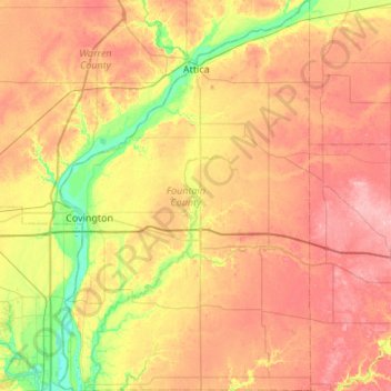
Name: Fountain County topographic map, elevation, terrain.
Location: Fountain County, Indiana, United States (39.95245 -87.44019 40.36648 -87.09014)
Average elevation: 676 ft
Minimum elevation: 472 ft
Maximum elevation: 873 ft
According to the 2010 United States Census, the county has a total area of 397.88 square miles (1,030.5 km2), of which 395.66 square miles (1,024.8 km2) (or 99.44%) is land and 2.22 square miles (5.7 km2) (or 0.56%) is water. Elevations range from 770 feet (230 m) above sea level in the northeastern part of the county to 465 feet (142 m) in the southwest where the Wabash River leaves the county. The county is within the drainage basin of the Wabash River, sloping to the southwest. It is covered with loess ranging in thickness from a few inches to more than 7 feet (2.1 m). Approximately 84 percent of the county's land is use for agriculture.
Other topographic maps
Click on a map to view its topography, its elevation and its terrain.
Blanford
United States > Indiana > Vermillion County
Blanford, Vermillion County, Indiana, 47831, United States
Average elevation: 574 ft
Indianapolis
United States > Indiana > Indianapolis
Indianapolis, Marion County, Indiana, 46204, United States
Average elevation: 791 ft
Fort Wayne
United States > Indiana > Allen County
Fort Wayne, Allen County, Indiana, United States
Average elevation: 807 ft
Versailles
United States > Indiana > Ripley County
Versailles, Ripley County, Indiana, United States
Average elevation: 938 ft
Lafayette
United States > Indiana > Tippecanoe County
Lafayette, Tippecanoe County, Indiana, United States
Average elevation: 633 ft
Tippecanoe County
Tippecanoe County, Indiana, United States
Average elevation: 692 ft
South Bend
United States > Indiana > Saint Joseph County
South Bend, Saint Joseph County, Indiana, United States
Average elevation: 774 ft
Evansville
United States > Indiana > Vanderburgh County
Evansville, Vanderburgh County, Indiana, United States
Average elevation: 400 ft
Bloomington
United States > Indiana > Monroe County
Bloomington, Monroe County, Indiana, United States
Average elevation: 791 ft
Valparaiso
United States > Indiana > Porter County
Valparaiso, Porter County, Indiana, United States
Average elevation: 771 ft
West Lafayette
United States > Indiana > Tippecanoe County
West Lafayette, Tippecanoe County, Indiana, United States
Average elevation: 630 ft
Queensville
United States > Indiana > Jennings County
Queensville, Jennings County, Indiana, 47625, United States
Average elevation: 702 ft
Twin Branch Dam
United States > Indiana > Saint Joseph County
Twin Branch Dam, Saint Joseph County, Indiana, United States
Average elevation: 732 ft
Noblesville
United States > Indiana > Hamilton County
Noblesville, Hamilton County, Indiana, 46060, United States
Average elevation: 817 ft
Paragon
United States > Indiana > Morgan County
Paragon, Morgan County, Indiana, United States
Average elevation: 577 ft
Indiana Dunes State Park
United States > Indiana > Porter County > Chesterton
Indiana Dunes State Park, 1600, Chesterton, Porter County, Indiana, 46304, United States
Average elevation: 610 ft
North Gate
United States > Indiana > Bartholomew County
North Gate, Bartholomew County, Indiana, 47280, United States
Average elevation: 646 ft
Saint Joseph County
Saint Joseph County, Indiana, United States
Average elevation: 784 ft
Brekenridge Park
United States > Indiana > Warrick County > Boonville
Brekenridge Park, Boonville, Warrick County, Indiana, United States
Average elevation: 413 ft
Eagle Creek Park
United States > Indiana > Marion County > Indianapolis
Eagle Creek Park, Indianapolis, Marion County, Indiana, 46253, United States
Average elevation: 840 ft
Koontz Lake
United States > Indiana > Starke County
Koontz Lake, Starke County, Indiana, United States
Average elevation: 725 ft
Princeton
United States > Indiana > Gibson County
Princeton, Gibson County, Indiana, 47670, United States
Average elevation: 489 ft
Hamilton County
Hamilton County, Indiana, United States
Average elevation: 856 ft
Perkins
United States > Indiana > Newton County
Perkins, Newton County, Indiana, United States
Average elevation: 692 ft
Old Pekin
United States > Indiana > Washington County
Old Pekin, Washington County, Indiana, 47165, United States
Average elevation: 751 ft
Nineveh
United States > Indiana > Johnson County
Nineveh, Johnson County, Indiana, United States
Average elevation: 781 ft
Portage
United States > Indiana > Porter County
Portage, Porter County, Indiana, United States
Average elevation: 623 ft
Plymouth
United States > Indiana > Marshall County
Plymouth, Marshall County, Indiana, 46563, United States
Average elevation: 810 ft
Syracuse
United States > Indiana > Kosciusko County
Syracuse, Kosciusko County, Indiana, United States
Average elevation: 876 ft
Bluffton
United States > Indiana > Wells County
Bluffton, Wells County, Indiana, 46714, United States
Average elevation: 833 ft
Rock Hill
United States > Indiana > Spencer County
Rock Hill, Spencer County, Indiana, United States
Average elevation: 407 ft
York
United States > Indiana > Steuben County
York, Steuben County, Indiana, United States
Average elevation: 1,050 ft
Berlien
United States > Indiana > Steuben County
Berlien, Steuben County, Indiana, United States
Average elevation: 1,024 ft
Indianapolis
United States > Indiana > Marion County
Indianapolis, Marion County, Indiana, United States
Average elevation: 791 ft
Montpelier
United States > Indiana > Blackford County
Montpelier, Blackford County, Indiana, 47359, United States
Average elevation: 873 ft
Alvarado
United States > Indiana > Steuben County
Alvarado, Steuben County, Indiana, United States
Average elevation: 958 ft
Metz
United States > Indiana > Steuben County
Metz, Steuben County, Indiana, United States
Average elevation: 974 ft
Chain O'Lakes State Park
United States > Indiana > Noble County
Chain O'Lakes State Park, 9, Noble County, Indiana, United States
Average elevation: 951 ft
New Palestine
United States > Indiana > Hancock County
New Palestine, Hancock County, Indiana, United States
Average elevation: 830 ft
Spring Grove
United States > Indiana > Wayne County
Spring Grove, Wayne County, Indiana, United States
Average elevation: 984 ft
Brown County State Park
United States > Indiana > Nashville
Brown County State Park, Nashville, Brown County, Indiana, United States
Average elevation: 735 ft
Union City
United States > Indiana > Randolph County
Union City, Randolph County, Indiana, United States
Average elevation: 1,093 ft
Shirley
United States > Indiana > Hancock County
Shirley, Hancock County, Indiana, United States
Average elevation: 1,024 ft
Knightstown
United States > Indiana > Henry County
Knightstown, Henry County, Indiana, United States
Average elevation: 935 ft
New Winchester
United States > Indiana > Hendricks County
New Winchester, Hendricks County, Indiana, United States
Average elevation: 948 ft