Geolocate

Metz topographic map

Click on the map to display elevation.

About this map

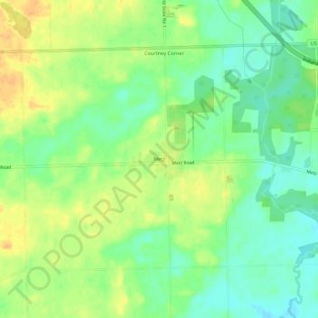
Name: Metz topographic map, elevation, terrain.

Location: Metz, Steuben County, Indiana, United States (41.59616 -84.85940 41.63616 -84.81940)

Average elevation: 974 ft

Minimum elevation: 922 ft

Maximum elevation: 1,030 ft

Steuben County trails, hiking, mountain biking, running and outdoor activities

Other topographic maps

Click on a map to view its topography, its elevation and its terrain.

Clear Lake

United States > Indiana > Steuben County

Average elevation: 1,053 ft

Hamilton

United States > Indiana > Steuben County

Average elevation: 928 ft

Pokagon State Park

United States > Indiana > Steuben County

Average elevation: 1,001 ft

Hudson

United States > Indiana > Steuben County

Average elevation: 984 ft

Orland

United States > Indiana > Steuben County

Average elevation: 955 ft

Long Lake

United States > Indiana > Steuben County > Long Lake

Average elevation: 1,053 ft

Gear up for your next adventure:

🔭Compact Binoculars - HD vision for scouting terrain and identifying distant landmarks
🥤Water Filter Bottle - All‑in‑one filter bottle for safe hydration
🌄Hiking Binoculars - Compact binoculars for scenic views and trail spotting
🥘Titanium Cookware - Durable, featherlight pots and pans for backpacking
🎁Geography Themed Gifts - Unique gift ideas for map lovers and geography enthusiasts

As an Amazon Associate, this site earns from qualifying purchases at no extra cost to you.