
Hayden topographic map
Click on the map to display elevation.
About this map
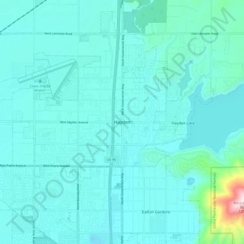
Name: Hayden topographic map, elevation, terrain.
Location: Hayden, Kootenai County, Idaho, 83835, United States (47.71906 -116.82668 47.79906 -116.74668)
Average elevation: 2,352 ft
Minimum elevation: 2,146 ft
Maximum elevation: 4,101 ft
Kootenai County trails, hiking, mountain biking, running and outdoor activities
Other topographic maps
Click on a map to view its topography, its elevation and its terrain.
Lake Coeur d'Alene
United States > Idaho > Kootenai County > Harrison
The lake's elevation varies from 2,128 feet (649 m) above sea level in the summer to up to 7 feet (2.1 m) lower in the winter, controlled by the Post Falls Dam 9 miles (14 km) below the lake on the Spokane River.
Average elevation: 2,713 ft