
Make a donation
Gear up for your next adventure:
As an Amazon Associate, this site earns from qualifying purchases at no extra cost to you.
Area C (Sasquatch Country) topographic map
Click on the map to display elevation.
Make a donation
Gear up for your next adventure:
As an Amazon Associate, this site earns from qualifying purchases at no extra cost to you.
About this map
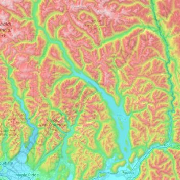
Name: Area C (Sasquatch Country) topographic map, elevation, terrain.
Average elevation: 3,241 ft
Minimum elevation: -7 ft
Maximum elevation: 9,236 ft
Make a donation
Gear up for your next adventure:
As an Amazon Associate, this site earns from qualifying purchases at no extra cost to you.
Other topographic maps
Click on a map to view its topography, its elevation and its terrain.
Fraser River
Canada > British Columbia > Fraser Valley Regional District > Chilliwack > Minto Landing
Average elevation: 328 ft
Eagle Mountain
Canada > British Columbia > Fraser Valley Regional District > Abbotsford
Average elevation: 420 ft
Cultus Lake
Canada > British Columbia > Fraser Valley Regional District > Area H (Cultus Lake/Columbia Valley) > Cultus Lake
Average elevation: 627 ft
Grotto Falls
Canada > British Columbia > Fraser Valley Regional District > Area F (McConnell Creek/Hatzic Prairie)
Average elevation: 2,346 ft
Make a donation
Gear up for your next adventure:
As an Amazon Associate, this site earns from qualifying purchases at no extra cost to you.
Calkins Creek
Canada > British Columbia > Fraser Valley Regional District > Chilliwack
Average elevation: 335 ft
Ruby Creek
Canada > British Columbia > Fraser Valley Regional District > Skawahlook > Ruby Creek
Average elevation: 554 ft
Chilliwack
Canada > British Columbia > Fraser Valley Regional District > Chilliwack
Average elevation: 1,286 ft
Abbotsford
Canada > British Columbia > Fraser Valley Regional District > Abbotsford
Average elevation: 377 ft
Make a donation
Gear up for your next adventure:
As an Amazon Associate, this site earns from qualifying purchases at no extra cost to you.
Great Bear Peak
Canada > British Columbia > Fraser Valley Regional District > Area B (South Fraser Canyon/Sunshine Valley)
Average elevation: 4,380 ft