
Alfafar topographic map
Click on the map to display elevation.
About this map
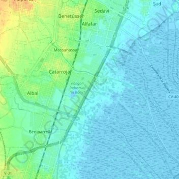
Name: Alfafar topographic map, elevation, terrain.
Location: Alfafar, l'Horta Sud, Valencian Community, 46910, Spain (39.36534 -0.40352 39.42850 -0.33007)
Average elevation: 20 ft
Minimum elevation: -13 ft
Maximum elevation: 92 ft
Other topographic maps
Click on a map to view its topography, its elevation and its terrain.
Desert de les Palmes
Spain > Valencian Community > Castelló / Castellón > Benicàssim / Benicasim
Average elevation: 1,214 ft
Vila-real
Spain > Valencian Community > Castelló / Castellón > Vila-real > Vila-real
Average elevation: 138 ft
Jardí botànic
Spain > Valencian Community > Castelló / Castellón > Todolella
Average elevation: 2,779 ft
Cim del Montnegro
Spain > Valencian Community > Castelló / Castellón > Borriol
Average elevation: 1,135 ft