
Make a donation
Gear up for your next adventure:
As an Amazon Associate, this site earns from qualifying purchases at no extra cost to you.
Piran / Pirano topographic map
Click on the map to display elevation.
Make a donation
Gear up for your next adventure:
As an Amazon Associate, this site earns from qualifying purchases at no extra cost to you.
Piran / Pirano
The Municipality of Piran borders Croatia to the south and the municipalities of Izola and Koper to the east, and it faces Italy across the Gulf of Trieste and the Adriatic Sea. The highest point, Baretovec pri Padni, has an elevation of 289 meters (948 ft).
Make a donation
Gear up for your next adventure:
As an Amazon Associate, this site earns from qualifying purchases at no extra cost to you.
About this map
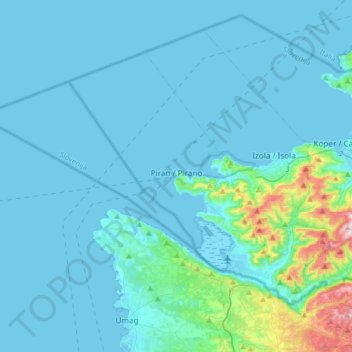
Name: Piran / Pirano topographic map, elevation, terrain.
Average elevation: 108 ft
Minimum elevation: -10 ft
Maximum elevation: 1,224 ft
Make a donation
Gear up for your next adventure:
As an Amazon Associate, this site earns from qualifying purchases at no extra cost to you.
Other topographic maps
Click on a map to view its topography, its elevation and its terrain.
Triglav
Triglav (pronounced [ˈtɾiːɡlau̯]; German: Terglau; Italian: Tricorno), with an elevation of 2,863.65 metres (9,395.2 ft), is the highest mountain in Slovenia and the highest peak of the Julian Alps. The mountain is the pre-eminent symbol of the Slovene nation, appearing on the coat of arms and flag of…
Average elevation: 7,090 ft
Make a donation
Gear up for your next adventure:
As an Amazon Associate, this site earns from qualifying purchases at no extra cost to you.
Make a donation
Gear up for your next adventure:
As an Amazon Associate, this site earns from qualifying purchases at no extra cost to you.
Murska Sobota
Annual rainfall in Murska Sobota is among the lowest in Slovenia. Characterized by the instability of rainfall, severe droughts are frequent. It has a warm-summer humid continental climate (Dfb) that is uncommon in Slovenia except at higher elevations,
Average elevation: 627 ft
Make a donation
Gear up for your next adventure:
As an Amazon Associate, this site earns from qualifying purchases at no extra cost to you.
Kras
It lies between the Vipava Valley, the low hills surrounding the valley, the westernmost part of the Brkini Hills, northern Istria, and the Gulf of Trieste. The western edge of the plateau also marks the traditional ethnic border between Italians and Slovenes. The region gave its name to karst topography. For…
Average elevation: 1,388 ft
Make a donation
Gear up for your next adventure:
As an Amazon Associate, this site earns from qualifying purchases at no extra cost to you.
Ljubljana
Ljubljana has an elevation of 295 meters (968 ft) The city centre, located along the Ljubljanica River, has an elevation of 298 meters (978 ft). Ljubljana Castle, which sits atop Castle Hill (Grajski grič) south of the city centre, has an elevation of 366 meters (1,201 ft). The highest point of the city,…
Average elevation: 1,352 ft
Triglav
Triglav (pronounced [ˈtɾíːɡlaw]; German: Terglau; Italian: Tricorno), with an elevation of 2,863.65 metres (9,395 ft 2+1⁄8 in), is the highest mountain in Slovenia and the highest peak of the Julian Alps. The mountain is the pre-eminent symbol of the Slovene nation, appearing on the coat of arms and…
Average elevation: 7,090 ft
Make a donation
Gear up for your next adventure:
As an Amazon Associate, this site earns from qualifying purchases at no extra cost to you.
Triglav
Triglav (pronounced [ˈtɾiːɡlau̯]; German: Terglau; Italian: Tricorno), with an elevation of 2,863.65 metres (9,395 ft 2+1⁄8 in), is the highest mountain in Slovenia and the highest peak of the Julian Alps. The mountain is the pre-eminent symbol of the Slovene nation, appearing on the coat of arms and…
Average elevation: 7,090 ft
Mangart
Mangart or Mangrt is a mountain in the Julian Alps, located on the border between Italy and Slovenia. With an elevation of 2,679 metres (8,789 ft), it is the fourth-highest peak in Slovenia, after Triglav, Škrlatica and Mali Triglav. It was first climbed in 1794 by the naturalist Franz von Hohenwart. Mangart…
Average elevation: 5,906 ft
Make a donation
Gear up for your next adventure:
As an Amazon Associate, this site earns from qualifying purchases at no extra cost to you.
Make a donation
Gear up for your next adventure:
As an Amazon Associate, this site earns from qualifying purchases at no extra cost to you.
Make a donation
Gear up for your next adventure:
As an Amazon Associate, this site earns from qualifying purchases at no extra cost to you.
Triglav
Triglav (pronounced [ˈtɾíːɡlaw]; German: Terglau; Italian: Tricorno), with an elevation of 2,863.65 metres (9,395 ft 2+1⁄8 in), is the highest mountain in Slovenia and the highest peak of the Julian Alps. The mountain is the pre-eminent symbol of the Slovene nation, appearing on the coat of arms and…
Average elevation: 7,090 ft
Make a donation
Gear up for your next adventure:
As an Amazon Associate, this site earns from qualifying purchases at no extra cost to you.
Bovec
Bovec is located 136 kilometres (85 mi) from the capital Ljubljana, at an elevation of 434 m (1,424 ft). The settlement lies in the Bovec Basin of the upper Soča (Isonzo) River, below the eastern slopes of Mount Kanin in the Julian Alps, forming the border with Italy. The adjacent Trenta Valley in the…
Average elevation: 3,143 ft
Make a donation
Gear up for your next adventure:
As an Amazon Associate, this site earns from qualifying purchases at no extra cost to you.
Make a donation
Gear up for your next adventure:
As an Amazon Associate, this site earns from qualifying purchases at no extra cost to you.
Make a donation
Gear up for your next adventure:
As an Amazon Associate, this site earns from qualifying purchases at no extra cost to you.
Rogla
Rogla was attested in written sources in 1763–87 as Vitenska Planina and Wittenska Planina. The Slovene name Rogla is derived from the Slovene common noun rogla 'forked tree-covered mountain ridge', referring to the local topography.
Average elevation: 4,482 ft
Make a donation
Gear up for your next adventure:
As an Amazon Associate, this site earns from qualifying purchases at no extra cost to you.
Make a donation
Gear up for your next adventure:
As an Amazon Associate, this site earns from qualifying purchases at no extra cost to you.
Strmec na Predelu
Slovenia > Bovec > Log pod Mangartom
Strmec na Predelu (pronounced [ˈstəɾməts na pɾɛˈdeːlu]; Italian: Bretto di Sopra) is a settlement in the Municipality of Bovec in the Littoral region of Slovenia. It lies on the road to the Predel Pass. Another road, distinguished by being the road built at the highest elevation in Slovenia, splits off…
Average elevation: 3,743 ft
Make a donation
Gear up for your next adventure:
As an Amazon Associate, this site earns from qualifying purchases at no extra cost to you.
Make a donation
Gear up for your next adventure:
As an Amazon Associate, this site earns from qualifying purchases at no extra cost to you.
Make a donation
Gear up for your next adventure:
As an Amazon Associate, this site earns from qualifying purchases at no extra cost to you.
Make a donation
Gear up for your next adventure:
As an Amazon Associate, this site earns from qualifying purchases at no extra cost to you.
Make a donation
Gear up for your next adventure:
As an Amazon Associate, this site earns from qualifying purchases at no extra cost to you.
Golo
Golo is a clustered village with two settlement centers: the hamlets of Gorenje Golo (German: Obergolu) and Dolenje Golo (German: Untergolu). It lies along the road from Ig to Visoko northeast of Mount Mokrec (elevation: 1,059 meters or 3,474 feet). Golec Hill (elevation: 766 meters or 2,513 feet) rises to the…
Average elevation: 1,900 ft
Make a donation
Gear up for your next adventure:
As an Amazon Associate, this site earns from qualifying purchases at no extra cost to you.
Make a donation
Gear up for your next adventure:
As an Amazon Associate, this site earns from qualifying purchases at no extra cost to you.
Make a donation
Gear up for your next adventure:
As an Amazon Associate, this site earns from qualifying purchases at no extra cost to you.
Make a donation
Gear up for your next adventure:
As an Amazon Associate, this site earns from qualifying purchases at no extra cost to you.
Make a donation
Gear up for your next adventure:
As an Amazon Associate, this site earns from qualifying purchases at no extra cost to you.
Make a donation
Gear up for your next adventure:
As an Amazon Associate, this site earns from qualifying purchases at no extra cost to you.