
Krk topographic map
Interactive map
Click on the map to display elevation.
About this map
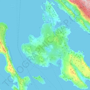
Name: Krk topographic map, elevation, terrain.
Location: Krk, Primorje-Gorski Kotar County, Croatia (44.93460 14.43080 45.24570 14.82048)
Average elevation: 312 ft
Minimum elevation: -13 ft
Maximum elevation: 3,553 ft
Other topographic maps
Click on a map to view its topography, its elevation and its terrain.
Rab
Croatia > Primorje-Gorski Kotar County > Town of Rab
Rab, Town of Rab, Municipality of Lopar, Primorje-Gorski Kotar County, Croatia
Average elevation: 85 ft
Crikvenica
Croatia > Primorje-Gorski Kotar County
Crikvenica, Grad Crikvenica, Primorje-Gorski Kotar County, 51260, Croatia
Average elevation: 377 ft
Grad Cres
Croatia > Primorje-Gorski Kotar County
Grad Cres, Primorje-Gorski Kotar County, Croatia
Average elevation: 203 ft
Novi Vinodolski
Croatia > Primorje-Gorski Kotar County
Novi Vinodolski, Grad Novi Vinodolski, Primorje-Gorski Kotar County, 51250, Croatia
Average elevation: 397 ft
Kastav
Croatia > Primorje-Gorski Kotar County
Kastav, Grad Kastav, Primorje-Gorski Kotar County, 51215, Croatia
Average elevation: 965 ft
Begovo Razdolje
Croatia > Primorje-Gorski Kotar County
Begovo Razdolje, Općina Mrkopalj, Primorje-Gorski Kotar County, Croatia
Average elevation: 3,560 ft
Malinska
Croatia > Primorje-Gorski Kotar County
Malinska, Općina Malinska-Dubašnica, Primorje-Gorski Kotar County, Croatia
Average elevation: 128 ft
Rijeka
Croatia > Primorje-Gorski Kotar County
Rijeka, Grad Rijeka, Primorje-Gorski Kotar County, 51000, Croatia
Average elevation: 1,266 ft
Divjake
Croatia > Primorje-Gorski Kotar County
Divjake, Općina Skrad, Primorje-Gorski Kotar County, 51311, Croatia
Average elevation: 2,290 ft
Bakar
Croatia > Primorje-Gorski Kotar County
Bakar, Grad Bakar, Primorje-Gorski Kotar County, 51222, Croatia
Average elevation: 561 ft
Grad Rijeka
Croatia > Primorje-Gorski Kotar County
Grad Rijeka, Primorje-Gorski Kotar County, Croatia
Average elevation: 686 ft
Lošinj
Croatia > Primorje-Gorski Kotar County > Veli Lošinj
Lošinj, Veli Lošinj, Grad Mali Lošinj, Primorje-Gorski Kotar County, Croatia
Average elevation: 46 ft