Geolocate

Rydal topographic map

Click on the map to display elevation.

About this map

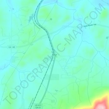
Name: Rydal topographic map, elevation, terrain.

Location: Rydal, Bartow County, Georgia, 30171, United States (34.31537 -84.73549 34.35537 -84.69549)

Average elevation: 896 ft

Minimum elevation: 778 ft

Maximum elevation: 1,447 ft

Bartow County trails, hiking, mountain biking, running and outdoor activities

Other topographic maps

Click on a map to view its topography, its elevation and its terrain.

White

United States > Georgia > Bartow County

Average elevation: 889 ft

Taylorsville

United States > Georgia > Bartow County

Average elevation: 745 ft

Weiss Lake

United States > Georgia > Bartow County > Cartersville

Average elevation: 906 ft

Gear up for your next adventure:

🔭Stargazing Telescopes - Perfect for camping in low-light pollution areas shown on maps
🚁Photography Drones - Capture stunning aerial views of landforms and topography
👟Trail Running Shoes - Lightweight shoes for trail runners
🩳Quick‑Dry Hiking Shorts - Comfortable and quick‑dry shorts for summer hiking
🔋Rechargeable Batteries - Power up your outdoor devices

As an Amazon Associate, this site earns from qualifying purchases at no extra cost to you.