Geolocate

Marmaton topographic map

Click on the map to display elevation.

About this map

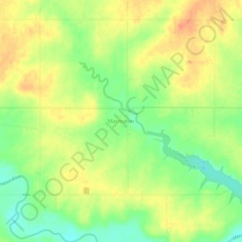
Name: Marmaton topographic map, elevation, terrain.

Location: Marmaton, Bourbon County, Kansas, United States (37.81199 -94.84469 37.85199 -94.80469)

Average elevation: 873 ft

Minimum elevation: 797 ft

Maximum elevation: 935 ft

Bourbon County trails, hiking, mountain biking, running and outdoor activities

Other topographic maps

Click on a map to view its topography, its elevation and its terrain.

Mapleton

United States > Kansas > Bourbon County

Average elevation: 876 ft

Redfield

United States > Kansas > Bourbon County

Average elevation: 863 ft

Fulton

United States > Kansas > Bourbon County

Average elevation: 827 ft

Bronson

United States > Kansas > Bourbon County

Average elevation: 1,060 ft

Gear up for your next adventure:

🔥Camping Stove - Portable stove for camping and backcountry cooking
🧭Compass with Lanyard - Easy‑carry compass for navigation
🧷Carabiner Set - Durable clips for gear attachment
📖Nature Tracking Books - Learn to track wildlife and terrain
📱Solar Portable Charger - Solar power bank for charging devices off‑grid

As an Amazon Associate, this site earns from qualifying purchases at no extra cost to you.