Geolocate

Chester topographic map

Click on the map to display elevation.

About this map

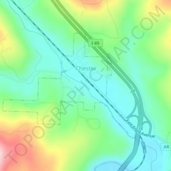
Name: Chester topographic map, elevation, terrain.

Location: Chester, Crawford County, Arkansas, 72934, United States (35.66987 -94.19147 35.68644 -94.16556)

Average elevation: 1,027 ft

Minimum elevation: 781 ft

Maximum elevation: 1,558 ft

Crawford County trails, hiking, mountain biking, running and outdoor activities

Other topographic maps

Click on a map to view its topography, its elevation and its terrain.

Artist Point

United States > Arkansas > Crawford County

Average elevation: 1,467 ft

Barcelona

United States > Arkansas > Crawford County

Average elevation: 774 ft

Uniontown

United States > Arkansas > Crawford County

Average elevation: 850 ft

Dora

United States > Arkansas > Crawford County

Average elevation: 531 ft

Alma

United States > Arkansas > Crawford County

Average elevation: 554 ft

Lee Creek

United States > Arkansas > Crawford County

Average elevation: 928 ft

Dyer

United States > Arkansas > Crawford County

Average elevation: 459 ft

Gear up for your next adventure:

🗃️Trail First Aid Kit - Essential kit for outdoor injuries and emergencies
❄️Traction Cleats - Prevent slips on icy trails during winter hikes
🦶Carbon Trekking Poles - Reduce knee impact on steep descents with ultra-light poles
💧Water Filtration Bottles - Safely drink from streams and lakes while exploring
🪓Survival Multi‑Tool - Versatile tool for camp and trail tasks

As an Amazon Associate, this site earns from qualifying purchases at no extra cost to you.