
East Side topographic map
Click on the map to display elevation.
About this map
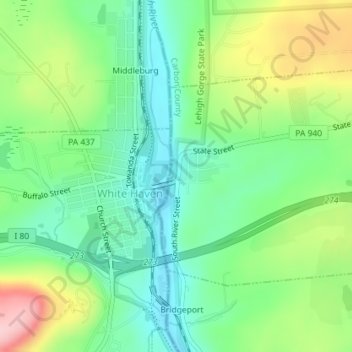
Name: East Side topographic map, elevation, terrain.
Location: East Side, Carbon County, Pennsylvania, United States (41.05356 -75.77123 41.07031 -75.74800)
Average elevation: 1,293 ft
Minimum elevation: 1,073 ft
Maximum elevation: 1,703 ft
Carbon County trails, hiking, mountain biking, running and outdoor activities
Other topographic maps
Click on a map to view its topography, its elevation and its terrain.
Lake Harmony
United States > Pennsylvania > Carbon County > Kidder Township
Average elevation: 1,808 ft
Beltzville Lake
United States > Pennsylvania > Carbon County > Towamensing Township
Average elevation: 886 ft
Leonardsville
United States > Pennsylvania > Carbon County > Kidder Township
Average elevation: 1,660 ft
White Bear Creek
United States > Pennsylvania > Carbon County > Summit Hill
Average elevation: 1,332 ft
Pisgah Mountain
United States > Pennsylvania > Carbon County > Summit Hill
Average elevation: 1,322 ft
Pleasant Corners
United States > Pennsylvania > Carbon County > Mahoning Township
Average elevation: 732 ft
Christian Corner
United States > Pennsylvania > Carbon County > Lower Towamensing Township
Average elevation: 741 ft
East Jim Thorpe
United States > Pennsylvania > Carbon County > Jim Thorpe > East Jim Thorpe
Average elevation: 892 ft