
Make a donation
Gear up for your next adventure:
As an Amazon Associate, this site earns from qualifying purchases at no extra cost to you.
Town of Rensselaerville topographic map
Click on the map to display elevation.
Make a donation
Gear up for your next adventure:
As an Amazon Associate, this site earns from qualifying purchases at no extra cost to you.
About this map
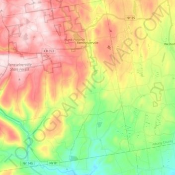
Name: Town of Rensselaerville topographic map, elevation, terrain.
Average elevation: 1,355 ft
Minimum elevation: 623 ft
Maximum elevation: 2,156 ft
Albany County trails, hiking, mountain biking, running and outdoor activities
Make a donation
Gear up for your next adventure:
As an Amazon Associate, this site earns from qualifying purchases at no extra cost to you.
Other topographic maps
Click on a map to view its topography, its elevation and its terrain.
Hartmans Corners
United States > New York > Albany County > Town of Guilderland
Average elevation: 266 ft
Make a donation
Gear up for your next adventure:
As an Amazon Associate, this site earns from qualifying purchases at no extra cost to you.
Henry Johnson Park
United States > New York > Albany County > City of Albany
Average elevation: 167 ft
Guilderland Center
United States > New York > Albany County > Town of Guilderland
Average elevation: 315 ft
Make a donation
Gear up for your next adventure:
As an Amazon Associate, this site earns from qualifying purchases at no extra cost to you.
Preston Hollow
United States > New York > Albany County > Town of Rensselaerville
Average elevation: 1,220 ft
South Bethlehem
United States > New York > Albany County > Town of Bethlehem
Average elevation: 236 ft
Make a donation
Gear up for your next adventure:
As an Amazon Associate, this site earns from qualifying purchases at no extra cost to you.
Horton Falls
United States > New York > Albany County > Town of New Scotland
Average elevation: 289 ft
Albany Pine Bush Preserve
United States > New York > Albany County > City of Albany
Average elevation: 279 ft
Make a donation
Gear up for your next adventure:
As an Amazon Associate, this site earns from qualifying purchases at no extra cost to you.
Albany
United States > New York > Albany County > Albany
The highest natural point in Albany is a USGS benchmark near the Loudonville Reservoir off Birch Hill Road, at 378 feet (115 m) above sea level. The lowest point is sea level at the Hudson River (the average water elevation is 2 feet (0.61 m)), which is still technically an estuary at Albany and is affected by…
Average elevation: 374 ft