Geolocate

Roanoke topographic map

Click on the map to display elevation.

About this map

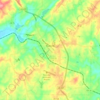
Name: Roanoke topographic map, elevation, terrain.

Location: Roanoke, Randolph County, Alabama, 36274, United States (33.10860 -85.41184 33.18588 -85.33033)

Average elevation: 827 ft

Minimum elevation: 686 ft

Maximum elevation: 997 ft

Randolph County trails, hiking, mountain biking, running and outdoor activities

Other topographic maps

Click on a map to view its topography, its elevation and its terrain.

Wadley

United States > Alabama > Randolph County

Average elevation: 686 ft

Melody Lane

United States > Alabama > Randolph County > Roanoke

Average elevation: 860 ft

Flat Rock

United States > Alabama > Randolph County

Average elevation: 830 ft

High Pine

United States > Alabama > Randolph County

Average elevation: 771 ft

Newell

United States > Alabama > Randolph County > Newell

Average elevation: 938 ft

Woodland

United States > Alabama > Randolph County

Average elevation: 1,027 ft

Roanoke

United States > Alabama > Randolph County > Roanoke

Average elevation: 823 ft

Gear up for your next adventure:

🌐World Map Poster - Decorative world maps with topographic info
🪵Folding Camp Saw - Compact saw for wood and campsite work
🥾Hiking Shoes - Durable and comfortable shoes for trail hiking
🧢Outdoor Hiking Hat - Sun protection hat for outdoor explorers
🪶Camping Sleeping Pad - Comfortable sleeping pad for backpacking

As an Amazon Associate, this site earns from qualifying purchases at no extra cost to you.