
Make a donation
Gear up for your next adventure:
As an Amazon Associate, this site earns from qualifying purchases at no extra cost to you.
Venango Township topographic map
Click on the map to display elevation.
Make a donation
Gear up for your next adventure:
As an Amazon Associate, this site earns from qualifying purchases at no extra cost to you.
About this map
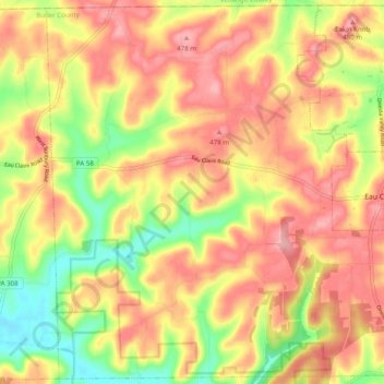
Name: Venango Township topographic map, elevation, terrain.
Location: Venango Township, Butler County, Pennsylvania, United States (41.10082 -79.88436 41.17311 -79.78570)
Average elevation: 1,414 ft
Minimum elevation: 1,178 ft
Maximum elevation: 1,585 ft
Butler County trails, hiking, mountain biking, running and outdoor activities
Make a donation
Gear up for your next adventure:
As an Amazon Associate, this site earns from qualifying purchases at no extra cost to you.
Other topographic maps
Click on a map to view its topography, its elevation and its terrain.
Make a donation
Gear up for your next adventure:
As an Amazon Associate, this site earns from qualifying purchases at no extra cost to you.
Make a donation
Gear up for your next adventure:
As an Amazon Associate, this site earns from qualifying purchases at no extra cost to you.
Make a donation
Gear up for your next adventure:
As an Amazon Associate, this site earns from qualifying purchases at no extra cost to you.
Buhls Station
United States > Pennsylvania > Butler County > Buhls Station
Average elevation: 1,102 ft
Petersville
United States > Pennsylvania > Butler County > Connoquenessing > Petersville
Average elevation: 1,207 ft
Make a donation
Gear up for your next adventure:
As an Amazon Associate, this site earns from qualifying purchases at no extra cost to you.
Glen Eden
United States > Pennsylvania > Butler County > Cranberry Township
Average elevation: 1,148 ft