
Thank you for supporting this site ❤️
Make a donation
Make a donation
Gear up for your next adventure:
As an Amazon Associate, this site earns from qualifying purchases at no extra cost to you.
丹麻镇 topographic map
Click on the map to display elevation.
Thank you for supporting this site ❤️
Make a donation
Make a donation
Gear up for your next adventure:
As an Amazon Associate, this site earns from qualifying purchases at no extra cost to you.
About this map
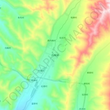
Name: 丹麻镇 topographic map, elevation, terrain.
Location: 丹麻镇, 互助土族自治县, 海东市, 青海省, 中国 (36.76182 102.07187 36.84182 102.15187)
Average elevation: 9,203 ft
Minimum elevation: 8,524 ft
Maximum elevation: 10,354 ft
Thank you for supporting this site ❤️
Make a donation
Make a donation
Gear up for your next adventure:
As an Amazon Associate, this site earns from qualifying purchases at no extra cost to you.