Geolocate

Cramerton topographic map

Click on the map to display elevation.

Cramerton

Cramerton is located at an elevation of 620 feet (189 m). Two topographic high points, Berry Mountain, elevation 922 feet (281 m), and Cramer Mountain, approximate elevation 850 feet (259 m), are located in the southwestern part of town.

Wikipedia (CC-BY-SA 3.0)

About this map

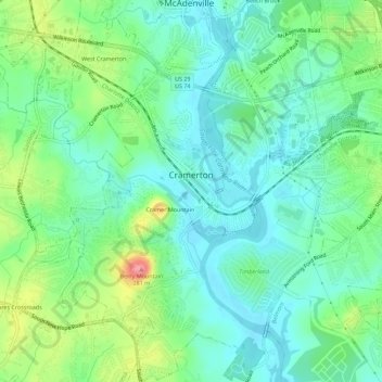
Name: Cramerton topographic map, elevation, terrain.

Location: Cramerton, Gaston County, North Carolina, 28032, United States (35.21391 -81.09848 35.25958 -81.05223)

Average elevation: 663 ft

Minimum elevation: 568 ft

Maximum elevation: 899 ft

Gaston County trails, hiking, mountain biking, running and outdoor activities

Other topographic maps

Click on a map to view its topography, its elevation and its terrain.

Tryon

United States > North Carolina > Gaston County

Average elevation: 942 ft

Hardins

United States > North Carolina > Gaston County

Average elevation: 741 ft

Lucia

United States > North Carolina > Gaston County

Average elevation: 728 ft

Crowders

United States > North Carolina > Gaston County

Average elevation: 712 ft

Springdale

United States > North Carolina > Gaston County

Average elevation: 758 ft

Belmont

United States > North Carolina > Gaston County > Belmont > Belmont

Average elevation: 659 ft

Alexis

United States > North Carolina > Gaston County

Average elevation: 833 ft

Brown Town

United States > North Carolina > Gaston County

Average elevation: 659 ft

Gear up for your next adventure:

Backpacking Tent - Lightweight and durable tent for multi‑day hikes
🏕️Tent Footprint - Protect your tent base from wear
🌡️Portable Weather Meter - Track weather conditions on the trail
🩳Quick‑Dry Hiking Shorts - Comfortable and quick‑dry shorts for summer hiking
🧯Emergency Survival Kit - All‑in‑one survival essentials for the backcountry

As an Amazon Associate, this site earns from qualifying purchases at no extra cost to you.