
Carp topographic map
Click on the map to display elevation.
About this map
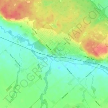
Name: Carp topographic map, elevation, terrain.
Location: Carp, Ottawa, Eastern Ontario, Ontario, K0A 1L0, Canada (45.32515 -76.05672 45.36515 -76.01672)
Average elevation: 361 ft
Minimum elevation: 282 ft
Maximum elevation: 466 ft
Other topographic maps
Click on a map to view its topography, its elevation and its terrain.
Rideau Canal
Most of the locks are still hand-operated. There are a total of 45 locks at 23 stations along the canal, plus two locks (locks 33 and 34) at the entrance to the Tay Canal (leading to Perth). The elevation between the Ottawa River and its summit at Upper Rideau Lake, is 83 metres (273 feet), the elevation…
Average elevation: 226 ft