Geolocate

Roosterville topographic map

Click on the map to display elevation.

About this map

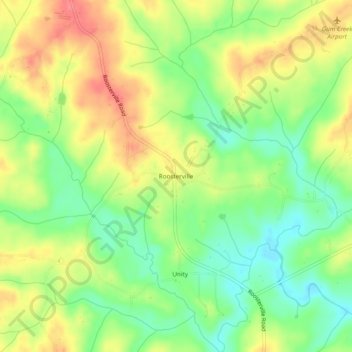
Name: Roosterville topographic map, elevation, terrain.

Location: Roosterville, Heard County, Georgia, 30170, United States (33.38345 -85.20383 33.42345 -85.16383)

Average elevation: 991 ft

Minimum elevation: 876 ft

Maximum elevation: 1,112 ft

Heard County trails, hiking, mountain biking, running and outdoor activities

Other topographic maps

Click on a map to view its topography, its elevation and its terrain.

Centralhatchee

United States > Georgia > Heard County

Average elevation: 827 ft

Corinth

United States > Georgia > Heard County

Average elevation: 764 ft

Ephesus

United States > Georgia > Heard County

Average elevation: 1,181 ft

Franklin

United States > Georgia > Heard County

Average elevation: 732 ft

Gear up for your next adventure:

🧺Microfiber Travel Towels - Compact and fast-drying towels for trail use
🧤Tactile Hiking Gloves - Keep hands warm while operating GPS and smartphone screens
🪄Magnetic Compass - Accurate compass for navigation
💧Water Purification System - Clean water on the trail with reliable purifiers
🧭Compass with Lanyard - Easy‑carry compass for navigation

As an Amazon Associate, this site earns from qualifying purchases at no extra cost to you.