
Make a donation
Gear up for your next adventure:
As an Amazon Associate, this site earns from qualifying purchases at no extra cost to you.
Willow Spring Mountain topographic map
Click on the map to display elevation.
Make a donation
Gear up for your next adventure:
As an Amazon Associate, this site earns from qualifying purchases at no extra cost to you.
About this map
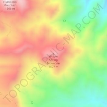
Name: Willow Spring Mountain topographic map, elevation, terrain.
Average elevation: 4,062 ft
Minimum elevation: 2,897 ft
Maximum elevation: 5,184 ft
Maricopa County trails, hiking, mountain biking, running and outdoor activities
Make a donation
Gear up for your next adventure:
As an Amazon Associate, this site earns from qualifying purchases at no extra cost to you.
Other topographic maps
Click on a map to view its topography, its elevation and its terrain.
White Tank Mountain Regional Park
United States > Arizona > Maricopa County
Average elevation: 2,188 ft
Anthem
United States > Arizona > Maricopa County > Anthem
Anthem is built on 5,856 acres (9.2 sq mi) at the base of Daisy Mountain and Gavilan Peak. The community's elevation ranges from 1,760 feet to 2,428 feet, with an average elevation of 1,863 feet. Approximately 36 percent of the community is preserved as open space, including 291 acres of open hillside.
Average elevation: 1,903 ft
Make a donation
Gear up for your next adventure:
As an Amazon Associate, this site earns from qualifying purchases at no extra cost to you.
Estrella Mountain Regional Park
United States > Arizona > Maricopa County > Avondale
Average elevation: 1,302 ft
Make a donation
Gear up for your next adventure:
As an Amazon Associate, this site earns from qualifying purchases at no extra cost to you.
Make a donation
Gear up for your next adventure:
As an Amazon Associate, this site earns from qualifying purchases at no extra cost to you.
Cave Creek Park - Thunderbird
United States > Arizona > Maricopa County > Phoenix
Average elevation: 1,316 ft
Make a donation
Gear up for your next adventure:
As an Amazon Associate, this site earns from qualifying purchases at no extra cost to you.
Make a donation
Gear up for your next adventure:
As an Amazon Associate, this site earns from qualifying purchases at no extra cost to you.
Make a donation
Gear up for your next adventure:
As an Amazon Associate, this site earns from qualifying purchases at no extra cost to you.
Desert Botanical Garden
United States > Arizona > Maricopa County > Phoenix
Average elevation: 1,276 ft