
Make a donation
Gear up for your next adventure:
As an Amazon Associate, this site earns from qualifying purchases at no extra cost to you.
Wittenbergen topographic map
Click on the map to display elevation.
Make a donation
Gear up for your next adventure:
As an Amazon Associate, this site earns from qualifying purchases at no extra cost to you.
About this map
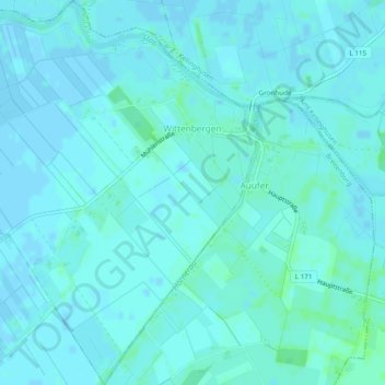
Name: Wittenbergen topographic map, elevation, terrain.
Average elevation: 7 ft
Minimum elevation: -7 ft
Maximum elevation: 26 ft
Make a donation
Gear up for your next adventure:
As an Amazon Associate, this site earns from qualifying purchases at no extra cost to you.
Other topographic maps
Click on a map to view its topography, its elevation and its terrain.
Rhinplate und Elbufer südlich Glückstadt
Deutschland > Schleswig-Holstein > Kreis Steinburg > Kollmar
Average elevation: 0 ft
Make a donation
Gear up for your next adventure:
As an Amazon Associate, this site earns from qualifying purchases at no extra cost to you.
Make a donation
Gear up for your next adventure:
As an Amazon Associate, this site earns from qualifying purchases at no extra cost to you.
Springhoe
Deutschland > Schleswig-Holstein > Kreis Steinburg > Hohenlockstedt
Average elevation: 66 ft
Kaaksburg
Deutschland > Schleswig-Holstein > Kreis Steinburg > Kaaks
Über ihre Entstehung und Funktion ist nicht viel bekannt. Der ovale Ringwall mit einem Durchmesser von 80 bzw. 100 m und einer Höhe von ca. 5 m wurde aus dunkler Erde aufgeworfen, während der Boden in der Umgebung sandig ist, weshalb angenommen wurde, dass das Material aus der im Südosten vorbeifließenden…
Average elevation: 36 ft
Make a donation
Gear up for your next adventure:
As an Amazon Associate, this site earns from qualifying purchases at no extra cost to you.
Springhoe
Deutschland > Schleswig-Holstein > Kreis Steinburg > Hohenlockstedt
Average elevation: 66 ft