
Alexander topographic map
Click on the map to display elevation.
About this map
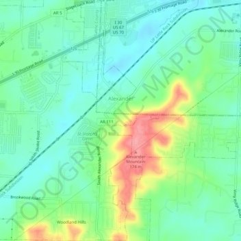
Name: Alexander topographic map, elevation, terrain.
Location: Alexander, Pulaski County, Arkansas, United States (34.60514 -92.47235 34.64631 -92.43800)
Average elevation: 377 ft
Minimum elevation: 282 ft
Maximum elevation: 584 ft
Pulaski County trails, hiking, mountain biking, running and outdoor activities
Other topographic maps
Click on a map to view its topography, its elevation and its terrain.
Two Rivers Park
United States > Arkansas > Pulaski County > Little Rock > Overlook Park
Average elevation: 364 ft
Merrivale
United States > Arkansas > Pulaski County > Little Rock > Merrivale
Average elevation: 299 ft
Overlook Park
United States > Arkansas > Pulaski County > Little Rock > Overlook Park
Average elevation: 400 ft