
Make a donation
Gear up for your next adventure:
As an Amazon Associate, this site earns from qualifying purchases at no extra cost to you.
Dacula topographic map
Click on the map to display elevation.
Make a donation
Gear up for your next adventure:
As an Amazon Associate, this site earns from qualifying purchases at no extra cost to you.
About this map
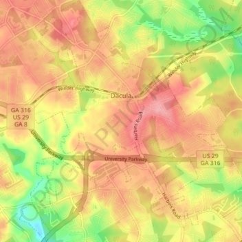
Name: Dacula topographic map, elevation, terrain.
Location: Dacula, Gwinnett County, Georgia, United States (33.95380 -83.92743 34.01135 -83.86037)
Average elevation: 1,027 ft
Minimum elevation: 820 ft
Maximum elevation: 1,165 ft
Gwinnett County trails, hiking, mountain biking, running and outdoor activities
Make a donation
Gear up for your next adventure:
As an Amazon Associate, this site earns from qualifying purchases at no extra cost to you.
Other topographic maps
Click on a map to view its topography, its elevation and its terrain.
Yellow River Post Office Site
United States > Georgia > Gwinnett County > Lilburn
Average elevation: 902 ft
Make a donation
Gear up for your next adventure:
As an Amazon Associate, this site earns from qualifying purchases at no extra cost to you.
Pine Ridge Country Club Estates
United States > Georgia > Gwinnett County > Lawrenceville
Average elevation: 1,060 ft
Make a donation
Gear up for your next adventure:
As an Amazon Associate, this site earns from qualifying purchases at no extra cost to you.