
Pitt Lake topographic map
Click on the map to display elevation.
About this map
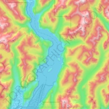
Name: Pitt Lake topographic map, elevation, terrain.
Average elevation: 2,162 ft
Minimum elevation: -26 ft
Maximum elevation: 5,679 ft
Other topographic maps
Click on a map to view its topography, its elevation and its terrain.
Barnes Lake
Canada > British Columbia > Metro Vancouver Regional District > Electoral Area A
Average elevation: 4,190 ft
Wreck Beach
Canada > British Columbia > Metro Vancouver Regional District > Electoral Area A
Average elevation: 105 ft
Barnston Island
Canada > British Columbia > Metro Vancouver Regional District > Electoral Area A
Average elevation: 20 ft
Passage Island
Canada > British Columbia > Metro Vancouver Regional District > Electoral Area A
Average elevation: 0 ft
Mount Eldee
Canada > British Columbia > Metro Vancouver Regional District > Electoral Area A
Average elevation: 3,366 ft
Seymour River
Canada > British Columbia > Metro Vancouver Regional District > Electoral Area A
Average elevation: 1,608 ft