
Leeds topographic map
Click on the map to display elevation.
About this map
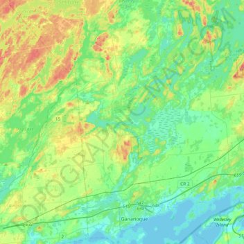
Name: Leeds topographic map, elevation, terrain.
Average elevation: 341 ft
Minimum elevation: 240 ft
Maximum elevation: 607 ft
Other topographic maps
Click on a map to view its topography, its elevation and its terrain.
Seeleys Bay
Canada > Ontario > Leeds and Grenville Counties > Leeds and the Thousand Islands > Seeley's Bay
Average elevation: 344 ft
Waterton
Canada > Ontario > Leeds and Grenville Counties > Leeds and the Thousand Islands > Waterton
Average elevation: 318 ft
Lansdowne
Canada > Ontario > Leeds and Grenville Counties > Leeds and the Thousand Islands
Average elevation: 331 ft
Junetown
Canada > Ontario > Leeds and Grenville Counties > Leeds and the Thousand Islands
Average elevation: 361 ft
Lyndhurst
Canada > Ontario > Leeds and Grenville Counties > Leeds and the Thousand Islands
Average elevation: 322 ft
Seeley's Bay
Canada > Ontario > Leeds and Grenville Counties > Leeds and the Thousand Islands
Average elevation: 348 ft
Outlet
Canada > Ontario > Leeds and Grenville Counties > Leeds and the Thousand Islands
Average elevation: 318 ft
Quabbin
Canada > Ontario > Leeds and Grenville Counties > Leeds and the Thousand Islands
Average elevation: 318 ft
Rochester Bay
Canada > Ontario > Leeds and Grenville Counties > Leeds and the Thousand Islands
Average elevation: 243 ft
Codfish Island
Canada > Ontario > Leeds and Grenville Counties > Leeds and the Thousand Islands
Average elevation: 259 ft
Why Island
Canada > Ontario > Leeds and Grenville Counties > Leeds and the Thousand Islands
Average elevation: 302 ft
Seeleys Bay
Canada > Ontario > Leeds and Grenville Counties > Leeds and the Thousand Islands > Seeley's Bay
Average elevation: 344 ft
Outlet
Canada > Ontario > Leeds and Grenville Counties > Leeds and the Thousand Islands
Average elevation: 318 ft