
Lansdowne topographic map
Click on the map to display elevation.
About this map
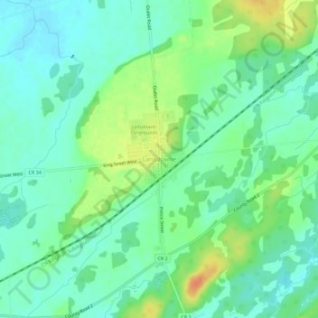
Name: Lansdowne topographic map, elevation, terrain.
Average elevation: 331 ft
Minimum elevation: 285 ft
Maximum elevation: 420 ft
Other topographic maps
Click on a map to view its topography, its elevation and its terrain.
Charleston Lake
Canada > Ontario > Leeds and Grenville Counties > Leeds and the Thousand Islands > Outlet
Average elevation: 338 ft
Thousand Islands National Park
Canada > Ontario > Leeds and Grenville Counties > Leeds and the Thousand Islands > Rockport
Average elevation: 381 ft
Gananoque Lake
Canada > Ontario > Leeds and Grenville Counties > Leeds and the Thousand Islands
Average elevation: 302 ft
Leeds
Canada > Ontario > Leeds and Grenville Counties > Leeds and the Thousand Islands
Average elevation: 341 ft
Leeds
Canada > Ontario > Leeds and Grenville Counties > Leeds and the Thousand Islands
Average elevation: 341 ft
Codfish Island
Canada > Ontario > Leeds and Grenville Counties > Leeds and the Thousand Islands
Average elevation: 259 ft
Why Island
Canada > Ontario > Leeds and Grenville Counties > Leeds and the Thousand Islands
Average elevation: 302 ft