Geolocate

Coaticook topographic map

Click on the map to display elevation.

About this map

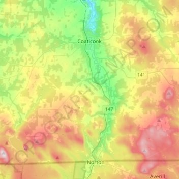
Name: Coaticook topographic map, elevation, terrain.

Location: Coaticook, Coaticook (MRC), Estrie, Quebec, Canada (45.00763 -71.93110 45.16014 -71.67282)

Average elevation: 1,440 ft

Minimum elevation: 682 ft

Maximum elevation: 2,421 ft

Other topographic maps

Click on a map to view its topography, its elevation and its terrain.

Perryboro

Canada > Quebec > Coaticook (MRC) > Saint-Herménégilde

Average elevation: 1,742 ft

Dufferin Heights

Canada > Quebec > Coaticook (MRC)

Average elevation: 1,247 ft

Moe's River

Canada > Quebec > Coaticook (MRC) > Compton

Average elevation: 925 ft

Barnston

Canada > Quebec > Coaticook (MRC) > Coaticook > Barnston

Average elevation: 1,371 ft

Crystal Lake

Canada > Quebec > Coaticook (MRC) > Stanstead (Ville)

Average elevation: 1,086 ft

Gear up for your next adventure:

🔪Outdoor Multitools - Essential survival tools for gear repair and field use
📷Action Cameras - Rugged cameras to document your journeys across rugged terrain
🧭Hiking Compass - Precision compass for reliable navigation in the wilderness
🧤Tactile Hiking Gloves - Keep hands warm while operating GPS and smartphone screens
🧭Map Reading Tools - Tools and kits for map navigation

As an Amazon Associate, this site earns from qualifying purchases at no extra cost to you.