Geolocate

Shady Point topographic map

Click on the map to display elevation.

About this map

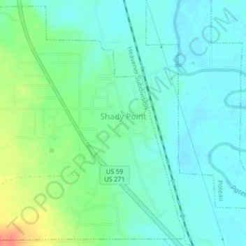
Name: Shady Point topographic map, elevation, terrain.

Location: Shady Point, Le Flore County, Oklahoma, 74956, United States (35.11641 -94.68230 35.14221 -94.65033)

Average elevation: 459 ft

Minimum elevation: 417 ft

Maximum elevation: 571 ft

Le Flore County trails, hiking, mountain biking, running and outdoor activities

Other topographic maps

Click on a map to view its topography, its elevation and its terrain.

Tombstone Mountain

United States > Oklahoma > Le Flore County

Average elevation: 1,496 ft

Trestle Ford

United States > Oklahoma > Le Flore County

Average elevation: 614 ft

Big Cedar

United States > Oklahoma > Le Flore County

Average elevation: 1,001 ft

Page

United States > Oklahoma > Le Flore County

Average elevation: 1,273 ft

Harvey Mountain

United States > Oklahoma > Le Flore County

Average elevation: 906 ft

Sunset Corner

United States > Oklahoma > Le Flore County

Average elevation: 482 ft

Octavia

United States > Oklahoma > Le Flore County > Octavia

Average elevation: 935 ft

Gear up for your next adventure:

🌡️Portable Weather Meter - Track weather conditions on the trail
🪶Paracord Bracelet - Survival bracelet with built‑in tools
📚USA Hiking Guide Books - Top trail guides and map books
🧣Merino Neck Gaiters - Multi-functional headwear for wind and sun protection
GPS Sports Watch - GPS watch for running, hiking and training

As an Amazon Associate, this site earns from qualifying purchases at no extra cost to you.