
Make a donation
Gear up for your next adventure:
As an Amazon Associate, this site earns from qualifying purchases at no extra cost to you.
Beitar Ilit topographic map
Click on the map to display elevation.
Make a donation
Gear up for your next adventure:
As an Amazon Associate, this site earns from qualifying purchases at no extra cost to you.
About this map
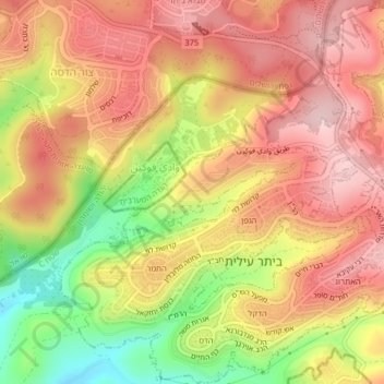
Name: Beitar Ilit topographic map, elevation, terrain.
Location: Beitar Ilit, Area C, Judea and Samaria, Palestinian Territory (31.68810 35.09368 31.72206 35.12962)
Average elevation: 2,277 ft
Minimum elevation: 1,788 ft
Maximum elevation: 2,595 ft
Make a donation
Gear up for your next adventure:
As an Amazon Associate, this site earns from qualifying purchases at no extra cost to you.
Other topographic maps
Click on a map to view its topography, its elevation and its terrain.
Make a donation
Gear up for your next adventure:
As an Amazon Associate, this site earns from qualifying purchases at no extra cost to you.
Make a donation
Gear up for your next adventure:
As an Amazon Associate, this site earns from qualifying purchases at no extra cost to you.
Make a donation
Gear up for your next adventure:
As an Amazon Associate, this site earns from qualifying purchases at no extra cost to you.
Khirbet an Nahla
Palestinian Territory > Judea and Samaria > Area C > Wadi Rahhal > Khirbet an Nahla
Average elevation: 2,625 ft