
Armstrong topographic map
Click on the map to display elevation.
About this map
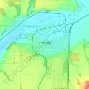
Name: Armstrong topographic map, elevation, terrain.
Average elevation: 1,237 ft
Minimum elevation: 1,152 ft
Maximum elevation: 1,401 ft
Other topographic maps
Click on a map to view its topography, its elevation and its terrain.
Big Peters Lake
Canada > British Columbia > Regional District of North Okanagan > Area E (Cherryville/East Creighton)
Average elevation: 6,070 ft
Silver Star Mountain Resort
Canada > British Columbia > Regional District of North Okanagan > Area C (Silver Star)
Average elevation: 5,197 ft
Lavington
Canada > British Columbia > Regional District of North Okanagan > Coldstream
Average elevation: 2,126 ft
Enderby Cliffs
Canada > British Columbia > Regional District of North Okanagan > Area F (Grindrod/Ashton Creek/Mabel Lake)
Average elevation: 2,989 ft
Curtis Lake
Canada > British Columbia > Regional District of North Okanagan > Area D (Trinity/West Creighton)
Average elevation: 4,357 ft
Grindrod
Canada > British Columbia > Regional District of North Okanagan > Area F (Grindrod/Ashton Creek/Mabel Lake)
Average elevation: 1,332 ft
Ellison Elemtary Park
Canada > British Columbia > Regional District of North Okanagan > Vernon
Average elevation: 1,309 ft
Vernon
Canada > British Columbia > Regional District of North Okanagan > Vernon
Average elevation: 2,795 ft
Armstrong
Canada > British Columbia > Regional District of North Okanagan > Armstrong > Armstrong
Average elevation: 1,621 ft
Spallumcheen
Canada > British Columbia > Regional District of North Okanagan
Average elevation: 2,746 ft
Kalamalka
Canada > British Columbia > Regional District of North Okanagan > Area B (Westside/Swan Lake/Kalamalka Lake)
Average elevation: 1,490 ft
Thompson Plateau
Canada > British Columbia > Regional District of North Okanagan > Area B (Westside/Swan Lake/Kalamalka Lake)
Average elevation: 4,147 ft
Cooke Creek
Canada > British Columbia > Regional District of North Okanagan > Area F (Grindrod/Ashton Creek/Mabel Lake)
Average elevation: 2,749 ft
Loon Lake
Canada > British Columbia > Regional District of North Okanagan > Area D (Trinity/West Creighton)
Average elevation: 4,462 ft
Cherryville
Canada > British Columbia > Regional District of North Okanagan > Area E (Cherryville/East Creighton)
Average elevation: 2,110 ft
Echo Lake Provincial Park
Canada > British Columbia > Regional District of North Okanagan > Area D (Trinity/West Creighton)
Average elevation: 3,671 ft
Monashee Mountains
Canada > British Columbia > Regional District of North Okanagan > Area F (Grindrod/Ashton Creek/Mabel Lake)
Average elevation: 5,528 ft
Silver Star Mountain
Canada > British Columbia > Regional District of North Okanagan > Area C (Silver Star)
Average elevation: 5,597 ft
Vernon Hill
Canada > British Columbia > Regional District of North Okanagan > Area C (Silver Star)
Average elevation: 4,058 ft
Cherryville
Canada > British Columbia > Regional District of North Okanagan > Area E (Cherryville/East Creighton)
Average elevation: 2,110 ft