
Make a donation
Gear up for your next adventure:
As an Amazon Associate, this site earns from qualifying purchases at no extra cost to you.
Greater Napanee topographic map
Click on the map to display elevation.
Make a donation
Gear up for your next adventure:
As an Amazon Associate, this site earns from qualifying purchases at no extra cost to you.
About this map
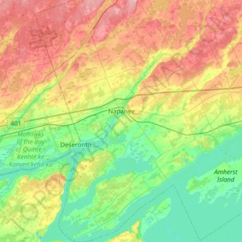
Name: Greater Napanee topographic map, elevation, terrain.
Average elevation: 371 ft
Minimum elevation: 217 ft
Maximum elevation: 646 ft
Make a donation
Gear up for your next adventure:
As an Amazon Associate, this site earns from qualifying purchases at no extra cost to you.
Other topographic maps
Click on a map to view its topography, its elevation and its terrain.
Weslemkoon Lake
Canada > Ontario > Lennox and Addington County > Addington Highlands
Average elevation: 1,063 ft
Make a donation
Gear up for your next adventure:
As an Amazon Associate, this site earns from qualifying purchases at no extra cost to you.
Bon Echo Lake
Canada > Ontario > Lennox and Addington County > Addington Highlands
Average elevation: 1,027 ft
Make a donation
Gear up for your next adventure:
As an Amazon Associate, this site earns from qualifying purchases at no extra cost to you.
Northbrook
Canada > Ontario > Lennox and Addington County > Addington Highlands
Average elevation: 853 ft
Lions Beaver Lake Park
Canada > Ontario > Lennox and Addington County > Stone Mills > Erinsville
Average elevation: 564 ft
Make a donation
Gear up for your next adventure:
As an Amazon Associate, this site earns from qualifying purchases at no extra cost to you.
Flinton
Canada > Ontario > Lennox and Addington County > Addington Highlands
Average elevation: 830 ft
Denbigh
Canada > Ontario > Lennox and Addington County > Addington Highlands
Average elevation: 1,243 ft
Make a donation
Gear up for your next adventure:
As an Amazon Associate, this site earns from qualifying purchases at no extra cost to you.
Make a donation
Gear up for your next adventure:
As an Amazon Associate, this site earns from qualifying purchases at no extra cost to you.
Kaladar
Canada > Ontario > Lennox and Addington County > Addington Highlands
Average elevation: 738 ft
Kaladar
Canada > Ontario > Lennox and Addington County > Addington Highlands
Average elevation: 738 ft