Geolocate

Tribbey topographic map

Click on the map to display elevation.

About this map

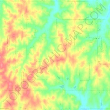
Name: Tribbey topographic map, elevation, terrain.

Location: Tribbey, Pottawatomie County, Oklahoma, United States (35.07230 -97.14205 35.13081 -97.03276)

Average elevation: 1,073 ft

Minimum elevation: 955 ft

Maximum elevation: 1,191 ft

Pottawatomie County trails, hiking, mountain biking, running and outdoor activities

Other topographic maps

Click on a map to view its topography, its elevation and its terrain.

Macomb

United States > Oklahoma > Pottawatomie County > Macomb

Average elevation: 978 ft

Centerview

United States > Oklahoma > Pottawatomie County

Average elevation: 961 ft

Harjo

United States > Oklahoma > Pottawatomie County

Average elevation: 932 ft

Trousdale

United States > Oklahoma > Pottawatomie County

Average elevation: 997 ft

Gear up for your next adventure:

🧭Pro Hiking Compasses - High-accuracy liquid-filled compasses for topographic orientation
💧Water Filtration Bottles - Safely drink from streams and lakes while exploring
🛠️Outdoor Gear Repair Kit - Essential tools to fix gear on the trail
🩳Quick‑Dry Hiking Shorts - Comfortable and quick‑dry shorts for summer hiking
🪶Camp Gear Gift Set - Perfect gift bundle for outdoor fans

As an Amazon Associate, this site earns from qualifying purchases at no extra cost to you.