Geolocate

Maud topographic map

Click on the map to display elevation.

About this map

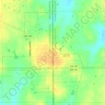
Name: Maud topographic map, elevation, terrain.

Location: Maud, Pottawatomie County, Oklahoma, United States (35.12406 -96.79165 35.14464 -96.76604)

Average elevation: 942 ft

Minimum elevation: 892 ft

Maximum elevation: 988 ft

Pottawatomie County trails, hiking, mountain biking, running and outdoor activities

Other topographic maps

Click on a map to view its topography, its elevation and its terrain.

Macomb

United States > Oklahoma > Pottawatomie County > Macomb

Average elevation: 978 ft

Centerview

United States > Oklahoma > Pottawatomie County

Average elevation: 961 ft

Harjo

United States > Oklahoma > Pottawatomie County

Average elevation: 932 ft

Trousdale

United States > Oklahoma > Pottawatomie County

Average elevation: 997 ft

Gear up for your next adventure:

🩳Quick‑Dry Hiking Shorts - Comfortable and quick‑dry shorts for summer hiking
👖Convertible Hiking Pants - Versatile zip-off pants for changing altitudes and temperatures
🏔️Mountain Trail Maps - High‑detail maps for popular peaks
GPS Sports Watch - GPS watch for running, hiking and training
🦶Hiking Gaiters - Keep debris and water out of your boots

As an Amazon Associate, this site earns from qualifying purchases at no extra cost to you.