
Peachtree Corners topographic map
Interactive map
Click on the map to display elevation.
About this map
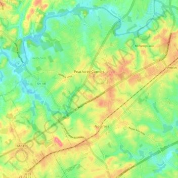
Name: Peachtree Corners topographic map, elevation, terrain.
Average elevation: 994 ft
Minimum elevation: 873 ft
Maximum elevation: 1,165 ft
Gwinnett County trails, hiking, mountain biking, running and outdoor activities
Other topographic maps
Click on a map to view its topography, its elevation and its terrain.
Pine Ridge Country Club Estates
United States > Georgia > Gwinnett County > Lawrenceville
Average elevation: 1,060 ft