Geolocate

Queimadela topographic map

Click on the map to display elevation.

About this map

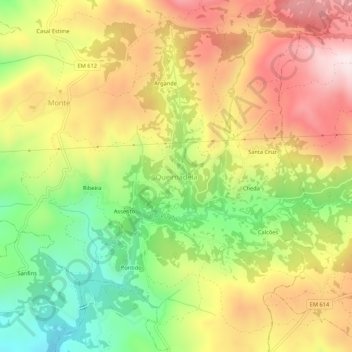
Name: Queimadela topographic map, elevation, terrain.

Location: Queimadela, Fafe, Braga, 4820-511, Portugal (41.49823 -8.16970 41.53823 -8.12970)

Average elevation: 1,913 ft

Minimum elevation: 1,093 ft

Maximum elevation: 2,717 ft

Other topographic maps

Click on a map to view its topography, its elevation and its terrain.

Queimadela

Portugal > Braga > Fafe

Average elevation: 1,795 ft

Monte e Queimadela

Portugal > Braga > Fafe

Average elevation: 1,827 ft

Revelhe

Portugal > Braga > Fafe

Average elevation: 1,447 ft

Travassós

Portugal > Braga > Fafe

Average elevation: 1,312 ft

Rio Ferro

Portugal > Braga > Fafe

Average elevation: 1,129 ft

Regadas

Portugal > Braga > Fafe

Average elevation: 1,565 ft

Cepães

Portugal > Braga > Fafe

Average elevation: 978 ft

Estorãos

Portugal > Braga > Fafe

Average elevation: 1,447 ft

Antime

Portugal > Braga > Fafe

Average elevation: 1,230 ft

Serafão

Portugal > Braga > Fafe

Average elevation: 1,102 ft

Silvares (São Martinho)

Portugal > Braga > Fafe

Average elevation: 1,516 ft

Arões (São Romão)

Portugal > Braga > Fafe

Average elevation: 1,250 ft

Fornelos

Portugal > Braga > Fafe

Average elevation: 1,033 ft

São Gens

Portugal > Braga > Fafe

Average elevation: 1,591 ft

Golães

Portugal > Braga > Fafe

Average elevation: 1,073 ft

Vinhós

Portugal > Braga > Fafe

Average elevation: 1,158 ft

Medelo

Portugal > Braga > Fafe

Average elevation: 1,211 ft

Ardegão

Portugal > Braga > Fafe

Average elevation: 1,788 ft

Quinchães

Portugal > Braga > Fafe

Average elevation: 1,575 ft

Ribeiros

Portugal > Braga > Fafe

Average elevation: 1,539 ft

Moreira do Rei

Portugal > Braga > Fafe

Average elevation: 1,998 ft

Gontim

Portugal > Braga > Fafe

É onde se encontra o Alto de Morgaír, o ponto mais alto do Município de Fafe, com 895,95 m de altitude.

Average elevation: 2,477 ft

Arões (Santa Cristina)

Portugal > Braga > Fafe

Average elevation: 988 ft

Várzea Cova

Portugal > Braga > Fafe

Average elevation: 2,172 ft

Pedraído

Portugal > Braga > Fafe

Average elevation: 2,070 ft

Arnozela

Portugal > Braga > Fafe

Average elevation: 1,896 ft

Freitas

Portugal > Braga > Fafe

Average elevation: 1,168 ft

Agrela e Serafão

Portugal > Braga > Fafe

Average elevation: 1,066 ft

Paços

Portugal > Braga > Fafe

Average elevation: 1,286 ft

Fareja

Portugal > Braga > Fafe

Average elevation: 846 ft

Quinchães

Portugal > Braga > Fafe

Average elevation: 1,575 ft

Rio Bugio

Portugal > Braga > Fafe

Average elevation: 1,483 ft

Serafão

Portugal > Braga > Fafe

Average elevation: 1,102 ft

Seidões

Portugal > Braga > Fafe

Average elevation: 1,959 ft

Gear up for your next adventure:

🧤Hiking Gloves - Protective gloves for rugged trails
🧭Pro Hiking Compasses - High-accuracy liquid-filled compasses for topographic orientation
🔌Solar Panel Charger - Charge gear sustainably outdoors
🪶Compact Camp Shovel - Folding shovel for campsite tasks
🪶Survival Guide Book - Expert advice for emergency preparedness

As an Amazon Associate, this site earns from qualifying purchases at no extra cost to you.