Geolocate

Zebbug topographic map

Click on the map to display elevation.

About this map

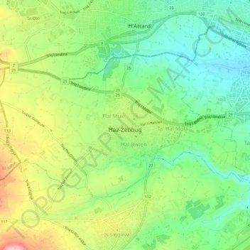
Name: Zebbug topographic map, elevation, terrain.

Location: Zebbug, Southern Region, Malta (35.86044 14.41189 35.88617 14.46667)

Average elevation: 299 ft

Minimum elevation: 72 ft

Maximum elevation: 650 ft

Other topographic maps

Click on a map to view its topography, its elevation and its terrain.

Wied iż-Żurrieq

Malta > Southern Region > Qrendi

Average elevation: 164 ft

Ta’ Dmejrek

Malta > Southern Region > Siġġiewi

Ta' Dmejrek is the highest point of Malta, located on the Dingli Cliffs, with an elevation of 253 metres (830 ft) above sea level.

Average elevation: 427 ft

Filfla

Malta > Southern Region > Żurrieq

Average elevation: 0 ft

Gear up for your next adventure:

🚪Portable Camp Chair - Foldable chair for comfort at camp
🖼️Topo Map Wall Art - Decorative topographic prints of famous peaks and regions
🔊Portable Camp Speaker - Music and alerts at camp
🌄Hiking Binoculars - Compact binoculars for scenic views and trail spotting
🥾Women's Hiking Boots - Top-rated trail boots with ankle support and superior grip

As an Amazon Associate, this site earns from qualifying purchases at no extra cost to you.