Geolocate

Sapele topographic map

Click on the map to display elevation.

About this map

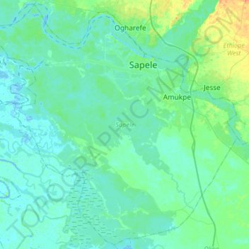
Name: Sapele topographic map, elevation, terrain.

Location: Sapele, Delta State, Nigeria (5.70443 5.51511 5.95823 5.77945)

Average elevation: 20 ft

Minimum elevation: -7 ft

Maximum elevation: 105 ft

Other topographic maps

Click on a map to view its topography, its elevation and its terrain.

Agbor

Nigeria > Delta State > Ika South

Average elevation: 525 ft

Warri

Nigeria > Delta State > Warri South

Average elevation: 13 ft

Asaba

Nigeria > Delta State > Oshimili South

Average elevation: 203 ft

Effurun

Nigeria > Delta State > Uvwie

Average elevation: 16 ft

Ughelli

Nigeria > Delta State > Ughelli North

Average elevation: 30 ft

Gear up for your next adventure:

👖Convertible Hiking Pants - Versatile zip-off pants for changing altitudes and temperatures
🪶Thermal Camp Blanket - Extra warmth for cold nights
🦶Hiking Gaiters - Keep debris and water out of your boots
🪶Multi‑Purpose Knife - Useful blade for camp and trail
🧤Tactile Hiking Gloves - Keep hands warm while operating GPS and smartphone screens

As an Amazon Associate, this site earns from qualifying purchases at no extra cost to you.