
Ali Sabieh Region topographic map
Interactive map
Click on the map to display elevation.
About this map
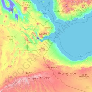
Name: Ali Sabieh Region topographic map, elevation, terrain.
Location: Ali Sabieh Region, Djibouti (8.61338 40.26992 13.81338 45.46992)
Average elevation: 2,047 ft
Minimum elevation: -505 ft
Maximum elevation: 10,741 ft
Other topographic maps
Click on a map to view its topography, its elevation and its terrain.
Rahra
Djibouti > Obock > Obock District
Rahra, Obock District, Obock, Djibouti
Average elevation: 2,464 ft
Balbala بلبالا
Djibouti > Djibouti > Balbala بلبالا
Balbala بلبالا, Djibouti, الشيخ موسى, Djibouti
Average elevation: 112 ft
Lake Assal
Lake Assal, مسار درة-بالهو / Piste Dorra - Balho, Dorra, Balha District, Tadjourah, Djibouti
Average elevation: -436 ft