
Dikhil topographic map
Interactive map
Click on the map to display elevation.
About this map
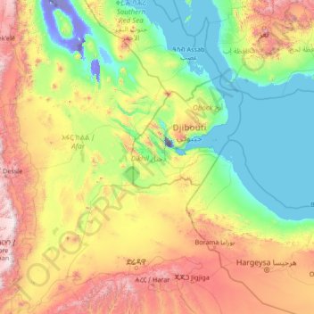
Name: Dikhil topographic map, elevation, terrain.
Location: Dikhil, Djibouti (8.82253 39.60938 14.02253 44.80938)
Average elevation: 2,385 ft
Minimum elevation: -505 ft
Maximum elevation: 11,926 ft
Other topographic maps
Click on a map to view its topography, its elevation and its terrain.
Rahra
Djibouti > Obock > Obock District
Rahra, Obock District, Obock, Djibouti
Average elevation: 2,464 ft
Balbala بلبالا
Djibouti > Djibouti > Balbala بلبالا
Balbala بلبالا, Djibouti, الشيخ موسى, Djibouti
Average elevation: 112 ft
Lake Assal
Lake Assal, مسار درة-بالهو / Piste Dorra - Balho, Dorra, Balha District, Tadjourah, Djibouti
Average elevation: -436 ft