Geolocate

Madison topographic map

Click on the map to display elevation.

About this map

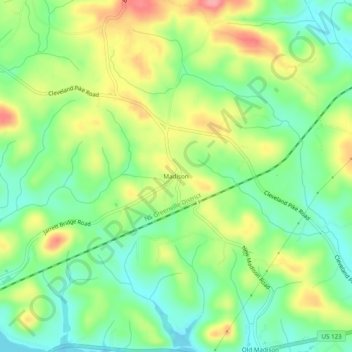
Name: Madison topographic map, elevation, terrain.

Location: Madison, Oconee County, South Carolina, United States (34.61232 -83.22794 34.65232 -83.18794)

Average elevation: 787 ft

Minimum elevation: 653 ft

Maximum elevation: 981 ft

Oconee County trails, hiking, mountain biking, running and outdoor activities

Other topographic maps

Click on a map to view its topography, its elevation and its terrain.

Seneca

United States > South Carolina > Oconee County

Average elevation: 869 ft

Lake Keowee

United States > South Carolina > Oconee County > Seneca

Average elevation: 958 ft

Westminster

United States > South Carolina > Oconee County

Average elevation: 892 ft

Walhalla

United States > South Carolina > Oconee County

Average elevation: 971 ft

Salem

United States > South Carolina > Oconee County

Average elevation: 1,037 ft

West Union

United States > South Carolina > Oconee County

Average elevation: 948 ft

Seneca

United States > South Carolina > Oconee County

Average elevation: 869 ft

Seneca

United States > South Carolina > Oconee County

Average elevation: 869 ft

Salem

United States > South Carolina > Oconee County

Average elevation: 1,037 ft

Gear up for your next adventure:

🛠️Backpacking Tool Kit - Essential toolkit for outdoor repairs
🪑Portable Camp Table - Compact table for campsite meals
🧤Hiking Gloves - Protective gloves for rugged trails
🧭Orienteering Set - Complete compass and map reading kit
🎒Hydration Pack - Hands‑free water reservoir for long hikes

As an Amazon Associate, this site earns from qualifying purchases at no extra cost to you.