
Make a donation
Gear up for your next adventure:
As an Amazon Associate, this site earns from qualifying purchases at no extra cost to you.
South District topographic map
Click on the map to display elevation.
Make a donation
Gear up for your next adventure:
As an Amazon Associate, this site earns from qualifying purchases at no extra cost to you.
About this map
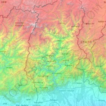
Name: South District topographic map, elevation, terrain.
Location: South District, Namchi, Sikkim, 737139, India (26.63333 87.71667 28.03333 89.11667)
Average elevation: 8,816 ft
Minimum elevation: 240 ft
Maximum elevation: 27,566 ft
Make a donation
Gear up for your next adventure:
As an Amazon Associate, this site earns from qualifying purchases at no extra cost to you.
Other topographic maps
Click on a map to view its topography, its elevation and its terrain.
Make a donation
Gear up for your next adventure:
As an Amazon Associate, this site earns from qualifying purchases at no extra cost to you.
Mangan
Mangan is the largest of the six districts of Sikkim. The landscape is mountainous with dense vegetation all the way up to the alpine altitude before thinning out to desert scrub towards the northern tundra. Numerous waterfalls astride the main road make the trip to this district extremely picturesque.
Average elevation: 14,459 ft
West Sikkim District
West Sikkim (now officially named as Geyzing District) is a district of the Indian state of Sikkim. Its headquarter is Geyzing, also known as Gyalshing. The district is a favourite with trekkers due to the high elevations. Other important towns include Pelling and Yuksom. Local people also call it as…
Average elevation: 8,812 ft
Make a donation
Gear up for your next adventure:
As an Amazon Associate, this site earns from qualifying purchases at no extra cost to you.
Make a donation
Gear up for your next adventure:
As an Amazon Associate, this site earns from qualifying purchases at no extra cost to you.
Gurudongmar
India > Sikkim > Chungthang
Gurudongmar Lake is one of the highest lakes in the world and in India, at an elevation of 5,430 m (17,800 ft) according to the Government of Sikkim. It is located in the Great Himalayas in the Mangan District in Indian state of Sikkim, and considered sacred by Buddhists and Sikhs. The lake is named after…
Average elevation: 17,165 ft
Make a donation
Gear up for your next adventure:
As an Amazon Associate, this site earns from qualifying purchases at no extra cost to you.
Make a donation
Gear up for your next adventure:
As an Amazon Associate, this site earns from qualifying purchases at no extra cost to you.
Make a donation
Gear up for your next adventure:
As an Amazon Associate, this site earns from qualifying purchases at no extra cost to you.
Mangan
Mangan is the largest of the six districts of Sikkim. The landscape is mountainous with dense vegetation all the way up to the alpine altitude before thinning out to desert scrub towards the northern tundra. Numerous waterfalls astride the main road make the trip to this district extremely picturesque.
Average elevation: 14,459 ft
Make a donation
Gear up for your next adventure:
As an Amazon Associate, this site earns from qualifying purchases at no extra cost to you.