
Bringhurst topographic map
Click on the map to display elevation.
About this map
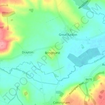
Name: Bringhurst topographic map, elevation, terrain.
Average elevation: 243 ft
Minimum elevation: 161 ft
Maximum elevation: 476 ft
Other topographic maps
Click on a map to view its topography, its elevation and its terrain.
Stoughton
United Kingdom > England > Leicestershire > Harborough > Stoughton
Average elevation: 400 ft
Gilmorton
United Kingdom > England > Leicestershire > Harborough > Gilmorton
Average elevation: 446 ft
Great Glen
United Kingdom > England > Leicestershire > Harborough > Great Glen
Average elevation: 377 ft
Broughton Astley
United Kingdom > England > Leicestershire > Harborough > Broughton Astley
Average elevation: 285 ft
Burton Overy
United Kingdom > England > Leicestershire > Harborough > Burton Overy
Average elevation: 413 ft
Smeeton Westerby
United Kingdom > England > Leicestershire > Harborough > Smeeton Westerby
Average elevation: 367 ft
Adrian's Spinney
United Kingdom > England > Leicestershire > Harborough > Stoughton
Average elevation: 371 ft
Kimcote and Walton
United Kingdom > England > Leicestershire > Harborough > Kimcote and Walton
Average elevation: 472 ft
Saddington
United Kingdom > England > Leicestershire > Harborough > Saddington
Average elevation: 417 ft
Little Stretton
United Kingdom > England > Leicestershire > Harborough > Little Stretton
Average elevation: 433 ft
Claybrooke Magna
United Kingdom > England > Leicestershire > Harborough > Claybrooke Magna
Average elevation: 335 ft
Stonton Wyville
United Kingdom > England > Leicestershire > Harborough > Stonton Wyville
Average elevation: 371 ft
Saddington Reservoir
United Kingdom > England > Leicestershire > Harborough > Saddington
Average elevation: 420 ft
Bruntingthorpe
United Kingdom > England > Leicestershire > Harborough > Bruntingthorpe
Average elevation: 433 ft
Dunton Bassett
United Kingdom > England > Leicestershire > Harborough > Dunton Bassett
Average elevation: 377 ft
Husbands Bosworth
United Kingdom > England > Leicestershire > Harborough > Husbands Bosworth
Average elevation: 466 ft
Scraptoft
United Kingdom > England > Leicestershire > Harborough > Scraptoft
Average elevation: 361 ft