
Make a donation
Gear up for your next adventure:
As an Amazon Associate, this site earns from qualifying purchases at no extra cost to you.
Dunagiri topographic map
Click on the map to display elevation.
Make a donation
Gear up for your next adventure:
As an Amazon Associate, this site earns from qualifying purchases at no extra cost to you.
About this map
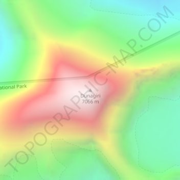
Name: Dunagiri topographic map, elevation, terrain.
Location: Dunagiri, Joshimath Tehsil, Chamoli, Uttarakhand, India (30.51557 79.86621 30.51567 79.86631)
Average elevation: 19,879 ft
Minimum elevation: 17,441 ft
Maximum elevation: 23,130 ft
Make a donation
Gear up for your next adventure:
As an Amazon Associate, this site earns from qualifying purchases at no extra cost to you.
Other topographic maps
Click on a map to view its topography, its elevation and its terrain.
Valley of Flowers National Park
India > Uttarakhand > Joshimath Tehsil > Ghangaria
Average elevation: 15,112 ft
Make a donation
Gear up for your next adventure:
As an Amazon Associate, this site earns from qualifying purchases at no extra cost to you.