
Make a donation
Gear up for your next adventure:
As an Amazon Associate, this site earns from qualifying purchases at no extra cost to you.
Santa Catarina topographic map
Click on the map to display elevation.
Make a donation
Gear up for your next adventure:
As an Amazon Associate, this site earns from qualifying purchases at no extra cost to you.
About this map
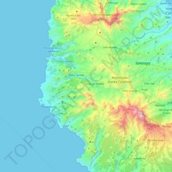
Name: Santa Catarina topographic map, elevation, terrain.
Location: Santa Catarina, 7310, Cape Verde (14.97344 -23.78162 15.20468 -23.61367)
Average elevation: 886 ft
Minimum elevation: -3 ft
Maximum elevation: 4,367 ft
Make a donation
Gear up for your next adventure:
As an Amazon Associate, this site earns from qualifying purchases at no extra cost to you.
Other topographic maps
Click on a map to view its topography, its elevation and its terrain.
Espargos
The highest point of Espargos is Monte Curral, elevation 109 meters, where the radar station and the control tower for the airport are located. The Amílcar Cabral International Airport is situated directly southwest of the city centre. The head offices of Cabo Verde Express are located at the airport. The…
Average elevation: 112 ft
Ribeira Grande de Santiago (Cidade Velha)
Cape Verde > Ribeira Grande de Santiago
Average elevation: 184 ft
Make a donation
Gear up for your next adventure:
As an Amazon Associate, this site earns from qualifying purchases at no extra cost to you.